
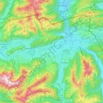
Gemeinde Kössen topographic map
Interactive map
Click on the map to display elevation.
About this map
Name: Gemeinde Kössen topographic map, elevation, terrain.
Location: Gemeinde Kössen, Bezirk Kitzbühel, Tirol, 6345, Oostenrijk (47.59728 12.31908 47.69638 12.52534)
Average elevation: 979 m
Minimum elevation: 562 m
Maximum elevation: 1,977 m
Other topographic maps
Click on a map to view its topography, its elevation and its terrain.
Thurnbichl
Oostenrijk > Tirol > Bezirk Kitzbühel > Gemeinde Kössen > Thurnbichl
Thurnbichl, Gemeinde Kössen, Bezirk Kitzbühel, Tirol, 6345, Oostenrijk
Average elevation: 699 m