
Thailand topographic map
Interactive map
Click on the map to display elevation.
Thailand
Thailand comprises several distinct geographic regions, partly corresponding to the provincial groups. The north of the country is the mountainous area of the Thai highlands, with the highest point being Doi Inthanon in the Thanon Thong Chai Range at 2,565 metres (8,415 ft) elevation. The northeast, Isan, consists of the Khorat Plateau, bordered to the east by the Mekong River. The centre of the country is dominated by the predominantly flat Chao Phraya river valley, which runs into the Gulf of Thailand.
About this map
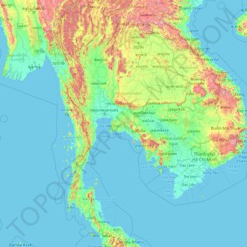
Name: Thailand topographic map, elevation, terrain.
Location: Thailand (5.61285 97.34381 20.46483 105.63681)
Average elevation: 156 m
Minimum elevation: -3 m
Maximum elevation: 2,557 m
Other topographic maps
Click on a map to view its topography, its elevation and its terrain.
Chiang Mai
The city is situated in a valley on a river basin in the Thai highlands and is on average at 300 m (1,000 ft) elevation. Chiang Mai's city centre sits west of the Ping River, a tributary to the Chao Phraya River, while the city's sprawl extends north-west, south-west, north-east and east of the river. To the…
Average elevation: 424 m
Bangkok
Bangkok is situated in the Chao Phraya River delta in Thailand's central plain. The river meanders through the city in a southerly direction, emptying into the Gulf of Thailand approximately 25 kilometres (16 mi) south of city centre. The area is flat and low-lying, with an average elevation of 1.5 metres (4…
Average elevation: 4 m
Ubon Ratchathani
Thailand > Ubon Ratchathani Province > Ubon Ratchathani
The elevation is 410 feet (125 meters). It is 615 kilometers from Bangkok.
Average elevation: 125 m