Geolocate

Kent Ridge Park topographic map

Interactive map

Click on the map to display elevation.

About this map

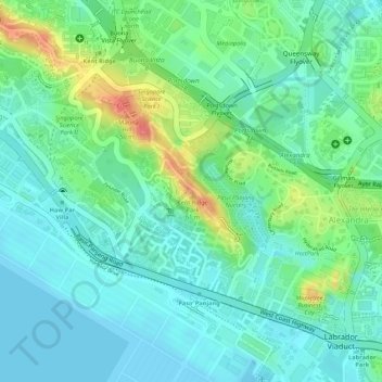
Name: Kent Ridge Park topographic map, elevation, terrain.

Location: Kent Ridge Park, Queenstown, Southwest, Singapore (1.27778 103.78567 1.28910 103.79575)

Average elevation: 21 m

Minimum elevation: 0 m

Maximum elevation: 67 m

Other topographic maps

Click on a map to view its topography, its elevation and its terrain.

Jurong Hill Park

Singapore > Southwest

Jurong Hill Park, Boon Lay, Southwest, Singapore

Average elevation: 11 m

Pandan Reservoir

Singapore > Southwest > Jurong East

Pandan Reservoir, Jurong East, Southwest, Singapore

Average elevation: 6 m

Jurong River

Singapore > Southwest > Jurong East

Jurong River, Jurong East, Southwest, Singapore

Average elevation: 7 m

Queenstown

Singapore > Southwest

Queenstown, Southwest, Singapore

Average elevation: 10 m

Clementi Woods

Singapore > Southwest

Clementi Woods, Clementi, Southwest, Singapore

Average elevation: 15 m

Yunnan Park

Singapore > Southwest

Yunnan Park, Yunnan, Jurong West, Southwest, Singapore

Average elevation: 19 m

Sungei Buloh Wetland Reserve

Singapore > Southwest > Singapore

Sungei Buloh Wetland Reserve, 301, Neo Tiew Crescent, Lim Chu Kang, Singapore, Southwest, 718925, Singapore

Average elevation: 6 m

One-North Park

Singapore > Southwest

One-North Park, Queenstown, Southwest, Singapore

Average elevation: 25 m

Pandan Reservoir

Singapore > Southwest

Pandan Reservoir, Southwest, Singapore

Average elevation: 6 m

Tanjong Pasir Laba

Singapore > Southwest

Tanjong Pasir Laba, Western Water Catchment, Southwest, 639937, Singapore

Average elevation: 4 m

West Coast Park

Singapore > Southwest > Queenstown

West Coast Park, Pasir Panjang, Queenstown, Southwest, 126784, Singapore

Average elevation: 9 m