
Alwar topographic map
Interactive map
Click on the map to display elevation.
About this map
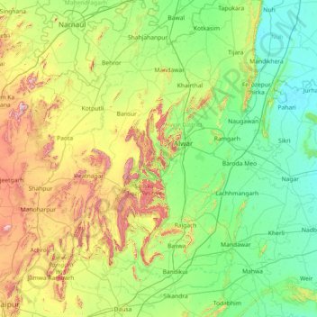
Name: Alwar topographic map, elevation, terrain.
Location: Alwar, Rajasthan, India (26.86000 75.86000 28.14000 77.14000)
Average elevation: 329 m
Minimum elevation: 184 m
Maximum elevation: 820 m
Other topographic maps
Click on a map to view its topography, its elevation and its terrain.
Kota
India > Rajasthan > Ladpura Tehsil
Kota, Ladpura Tehsil, Kota District, Rajasthan, 324001, India
Average elevation: 286 m
Sanganer
India > Rajasthan > Sarwar Tehsil
Sanganer, Sarwar Tehsil, Ajmer, Rajasthan, India
Average elevation: 361 m
Guru Shikhar, Abu
Guru Shikhar, Abu, Abu Road Tehsil, Sirohi, Rajasthan, 307501, India
Average elevation: 1,366 m