
Crawford County topographic map
Interactive map
Click on the map to display elevation.
About this map
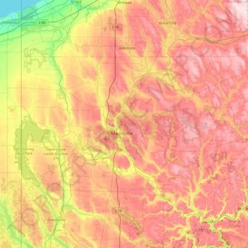
Name: Crawford County topographic map, elevation, terrain.
Location: Crawford County, Pennsylvania, United States of America (41.48043 -80.51939 41.85148 -79.61205)
Average elevation: 382 m
Minimum elevation: 171 m
Maximum elevation: 573 m
Other topographic maps
Click on a map to view its topography, its elevation and its terrain.
Delaware County
United States of America > Pennsylvania
Delaware County, Pennsylvania, United States of America
Average elevation: 76 m
Erie County
United States of America > Pennsylvania
Erie County, Pennsylvania, United States of America
Average elevation: 248 m
Lehigh County
United States of America > Pennsylvania
Lehigh County, Pennsylvania, United States of America
Average elevation: 186 m
Beaver County
United States of America > Pennsylvania
Beaver County, Pennsylvania, United States of America
Average elevation: 325 m
Bedford County
United States of America > Pennsylvania
Bedford County, Pennsylvania, United States of America
Average elevation: 491 m