
Lhassa topographic map
Interactive map
Click on the map to display elevation.
About this map
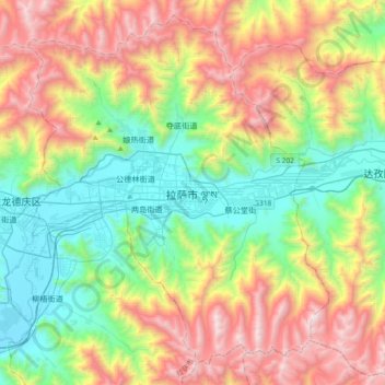
Name: Lhassa topographic map, elevation, terrain.
Average elevation: 4,380 m
Minimum elevation: 3,615 m
Maximum elevation: 5,654 m
Située sur le plateau du Tibet, au fond d'une vallée entourée de montagnes, son altitude de 3 650 m en fait l'une des villes les plus élevées au monde. Les montagnes entourant la ville s'élèvent à 5 000 m. La ville est longée par la rivière Kyi, qui traverse les montagnes Nyainqentanglha, et coule sur 315 km avant de se jeter dans le Brahmapoutre. Le Chakpori est une montagne sacrée de Lhassa.
Other topographic maps
Click on a map to view its topography, its elevation and its terrain.