
Khyber Pakhtunkhwa topographic map
Interactive map
Click on the map to display elevation.
About this map
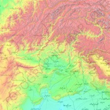
Name: Khyber Pakhtunkhwa topographic map, elevation, terrain.
Location: Khyber Pakhtunkhwa, Pakistan (31.94000 69.44000 37.06000 74.56000)
Average elevation: 2,135 m
Minimum elevation: 170 m
Maximum elevation: 7,856 m
Most precipitation falls as thunderstorms or snow during winter and spring, so that the climate at the lowest elevations is classed as Mediterranean (Csa), continental Mediterranean (Dsa) or semi-arid (BSk). Summers are extremely dry in the north of Chitral district and receive only a little rain in the south around Drosh.
Other topographic maps
Click on a map to view its topography, its elevation and its terrain.
Saraghrar I
Saraghrar I, Chitrāl District, Khyber Pakhtunkhwa, Pakistan
Average elevation: 6,780 m
Chitral
Pakistan > Khyber Pakhtunkhwa > Chitral
Chitral, Chitrāl District, Khyber Pakhtunkhwa, Pakistan
Average elevation: 2,047 m
Tirich Mir
Tirich Mir, Chitrāl District, Khyber Pakhtunkhwa, Pakistan
Average elevation: 6,886 m