
New Ireland topographic map
Interactive map
Click on the map to display elevation.
About this map
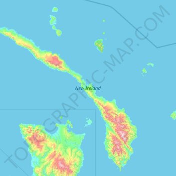
Name: New Ireland topographic map, elevation, terrain.
Location: New Ireland, Islands Region, Papua New Guinea (-4.85125 150.70168 -2.55300 153.11850)
Average elevation: 83 m
Minimum elevation: 0 m
Maximum elevation: 2,237 m
The island is part of two ecoregions. The New Britain-New Ireland lowland rain forests extend from sea level to 1000 meters elevation. The New Britain-New Ireland montane rain forests cover the mountains of New Ireland above 1000 meters elevation.
Other topographic maps
Click on a map to view its topography, its elevation and its terrain.
Likas
Papua New Guinea > New Ireland
Likas, New Ireland, Islands Region, Papua New Guinea
Average elevation: 42 m
Lavongai
Papua New Guinea > New Ireland
Lavongai, New Ireland, Islands Region, Papua New Guinea
Average elevation: 43 m