
Lusail topographic map
Interactive map
Click on the map to display elevation.
Lusail
Groundwater quality in the area is poor. On the city's border with the Persian Gulf, the groundwater elevation is 1 meter above sea level and flows east-to-west. Salinity levels are highest on the eastern side, at 40 ppt, compared to a low of 18 ppt in the western section; these levels are too high for consumption or use in agriculture. Because of the groundwater's high salinity, only salt- and drought-tolerant plants grow in this area. A geographic survey found 25 species of plants within city limits; all of which are found abundantly elsewhere on the peninsula.
About this map
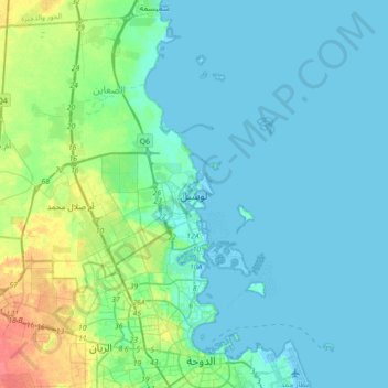
Name: Lusail topographic map, elevation, terrain.
Location: Lusail, Al-Daayen, Qatar (25.26289 51.35972 25.58289 51.67972)
Average elevation: 9 m
Minimum elevation: -4 m
Maximum elevation: 49 m