
Make a donation
Pickering topographic map
Click on the map to display elevation.
Make a donation
Pickering
The city covers an area of 231 square kilometres (89 sq mi) with an elevation of 89 metres (292 ft).
Make a donation
About this map
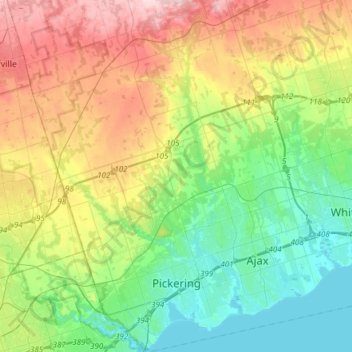
Name: Pickering topographic map, elevation, terrain.
Location: Pickering, Durham Region, Golden Horseshoe, Ontario, Canada (43.79307 -79.22004 44.01076 -79.00859)
Average elevation: 170 m
Minimum elevation: 72 m
Maximum elevation: 351 m
Make a donation
Other topographic maps
Click on a map to view its topography, its elevation and its terrain.
Make a donation
Make a donation
Darlington Provincial Park
Canada > Ontario > Durham Region > Clarington
Darlington Provincial Park is a provincial park in Ontario, Canada. It is located just south of Highway 401 in the city of Bowmanville. A small park, the topography is dominated by gentle hills formed by a terminal moraine deposited by glaciers at the end of the last Ice Age. The park borders on the northern…
Average elevation: 84 m
Make a donation
Make a donation
Make a donation
Make a donation
Make a donation
Make a donation
Make a donation
Make a donation
Make a donation