
Aegean topographic map
Interactive map
Click on the map to display elevation.
About this map
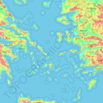
Name: Aegean topographic map, elevation, terrain.
Location: Aegean, Greece (35.23795 24.06581 40.10085 29.72970)
Average elevation: 124 m
Minimum elevation: -2 m
Maximum elevation: 2,305 m
Other topographic maps
Click on a map to view its topography, its elevation and its terrain.
Milos Regional Unit
Milos Regional Unit, South Aegean, Aegean, Greece, Milos
Average elevation: 24 m
Lazarus
Greece > Aegean > Samos Regional Unit > Municipal Unit of Vathy
Lazarus, Municipal Unit of Vathy, Municipality of Eastern Samos, Samos Regional Unit, Northern Aegean, Aegean, Greece
Average elevation: 722 m
Notio Aspronisi West
Notio Aspronisi West, Δήμος Λειψών, Kalmynos Regional Unit, South Aegean Region, Aegean, Greece
Average elevation: 2 m
Panteli
Greece > Aegean > Vromolithos
Panteli, Vromolithos, Δήμος Λέρου, Kalmynos Regional Unit, South Aegean Region, Aegean, 854 00, Greece
Average elevation: 33 m
Thira Municipal Unit
Greece > Aegean > Thira Municipal Unit
Thira Municipal Unit, Δήμος Θήρας, Thira Regional Unit, South Aegean Region, Aegean, Greece
Average elevation: 12 m
Chios
Greece > Aegean > Chios Regional Unit
Chios, Chios Regional Unit, Northern Aegean, Aegean, Greece
Average elevation: 99 m
Santorini
Greece > Aegean > Thira Municipal Unit
Santorini, Thira Municipal Unit, Δήμος Θήρας, Thira Regional Unit, South Aegean Region, Aegean, Greece
Average elevation: 30 m