
Oskaloosa topographic map
Interactive map
Click on the map to display elevation.
About this map
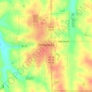
Name: Oskaloosa topographic map, elevation, terrain.
Location: Oskaloosa, Jefferson County, Kansas, United States (39.20512 -95.32384 39.22426 -95.30397)
Average elevation: 329 m
Minimum elevation: 298 m
Maximum elevation: 349 m
Other topographic maps
Click on a map to view its topography, its elevation and its terrain.
Winchester
United States > Kansas > Jefferson County
Winchester, Jefferson County, Kansas, United States
Average elevation: 352 m
Nortonville
United States > Kansas > Jefferson County
Nortonville, Jefferson County, Kansas, 66060, United States
Average elevation: 348 m
Valley Falls
United States > Kansas > Jefferson County
Valley Falls, Jefferson County, Kansas, United States
Average elevation: 288 m
Perry
United States > Kansas > Jefferson County
Perry, Jefferson County, Kansas, United States
Average elevation: 261 m
McLouth
United States > Kansas > Jefferson County
McLouth, Jefferson County, Kansas, United States
Average elevation: 350 m
Valley Falls
United States > Kansas > Jefferson County > Valley Falls > Valley Falls
Valley Falls, Jefferson County, Kansas, 66088, United States
Average elevation: 296 m