
Sint-Lambrechts-Herk topographic map
Interactive map
Click on the map to display elevation.
About this map
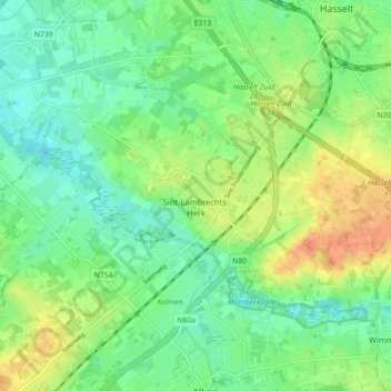
Name: Sint-Lambrechts-Herk topographic map, elevation, terrain.
Location: Sint-Lambrechts-Herk, Hasselt, Limburg, België (50.88566 5.26011 50.92150 5.34878)
Average elevation: 41 m
Minimum elevation: 25 m
Maximum elevation: 67 m
In het noorden stroomt nog de Waanbeek, die bij Stevoort in de Herk uitmondt. In het oosten van het gebied ligt een heuvelrug welke tot 45 meter hoogte reikt.
Other topographic maps
Click on a map to view its topography, its elevation and its terrain.
Rapertingen
België > Limburg > Hasselt > Hasselt
Rapertingen, Hasselt, Limburg, België
Average elevation: 49 m