
Stokrooie topographic map
Interactive map
Click on the map to display elevation.
About this map
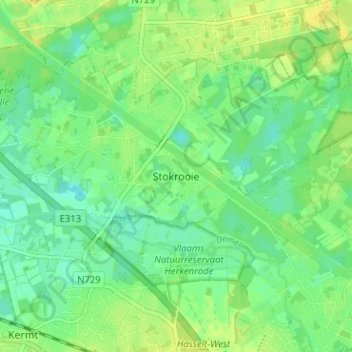
Name: Stokrooie topographic map, elevation, terrain.
Location: Stokrooie, Hasselt, Limburg, 3511, België (50.94630 5.26100 50.98630 5.30100)
Average elevation: 29 m
Minimum elevation: 19 m
Maximum elevation: 39 m
Other topographic maps
Click on a map to view its topography, its elevation and its terrain.
Rapertingen
België > Limburg > Hasselt > Hasselt
Rapertingen, Hasselt, Limburg, België
Average elevation: 49 m
Sint-Lambrechts-Herk
België > Limburg > Hasselt > Hasselt
Sint-Lambrechts-Herk, Hasselt, Limburg, België
Average elevation: 41 m