
Make a donation
Nova Scotia topographic map
Click on the map to display elevation.
Make a donation
Nova Scotia
Nova Scotia's topography is a diverse blend of rugged highlands, rolling hills, and fertile lowlands. The province's landscape is shaped by several upland regions, including the Southern Upland, North Mountain, and Cobequid Mountain, which are interspersed with extensive lowlands. The Southern Upland rises from the Atlantic coast to elevations between 180 and 210 meters (591 to 689 feet) inland, while the North Mountain runs parallel along the Bay of Fundy, creating fertile valleys like those of the Annapolis and Cornwallis rivers. Cape Breton Island, part of Nova Scotia, features the Cape Breton Highlands, a wild, wooded plateau peaking over 550 meters (1,804 feet) above sea level, contributing to the scenic character of Cape Breton Highlands National Park. The province's coastline is heavily indented, accounting for its length of approximately 400 km (249 miles). The coast is mostly rock with small isolated sand beaches in sheltered bays. The largest coastal features include St. Margarets Bay, Halifax Harbour/Bedford Basin, Cole Harbour, Musquodoboit Harbour, Jeddore Harbour, Ship Harbour, Sheet Harbour, and Ecum Secum Harbour. The province's topography spans from lush farmland in the Musquodoboit Valley to rocky and heavily forested rolling hills. It includes a number of islands and peninsulas, among them McNabs Island, Beaver Island, Melville Island, Deadman's Island, and Sable Island. This varied terrain, combined with over 3,000 lakes and numerous rivers, creates a rich and picturesque landscape.
Make a donation
About this map
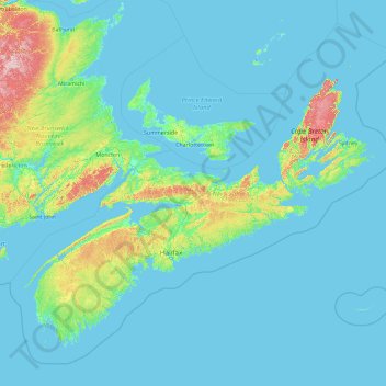
Name: Nova Scotia topographic map, elevation, terrain.
Location: Nova Scotia, Canada (43.18816 -66.68072 47.76107 -59.28871)
Average elevation: 41 m
Minimum elevation: -3 m
Maximum elevation: 746 m
Make a donation
Other topographic maps
Click on a map to view its topography, its elevation and its terrain.
Lund
Canada > British Columbia > qathet Regional District > Area A (Malaspina/Toba)
Average elevation: 57 m
Starkey Hill Conservation Area
Canada > Ontario > Wellington County > Puslinch > Arkell
Average elevation: 348 m
Little Current
Canada > Ontario > Manitoulin District > Northeastern Manitoulin and the Islands
Average elevation: 193 m
Make a donation
Make a donation
Make a donation
Miocene
Canada > British Columbia > Cariboo Regional District > Area F (Horsefly/Likely/150 Mile House)
Average elevation: 1,009 m
Make a donation
Waterton Park
Canada > Alberta > Division No. 3
It is located at the southwestern terminus of Highway 5, approximately 54 kilometres (34 mi) west of the Town of Cardston and 55 kilometres (34 mi) south of the Town of Pincher Creek. This hamlet is north of Glacier National Park in Montana. It has an elevation of 1,280 metres (4,200 ft).
Average elevation: 1,456 m
Make a donation
Make a donation
Eagle Creek
Canada > British Columbia > Cariboo Regional District > Area H (Canim Lake/Forest Grove)
Average elevation: 824 m
Mount Howard-Stowe
Canada > British Columbia > Cariboo Regional District > Area J (West Chilcotin)
Average elevation: 2,125 m