
Perlora topographic map
Interactive map
Click on the map to display elevation.
About this map
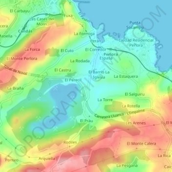
Name: Perlora topographic map, elevation, terrain.
Location: Perlora, Carreño, Asturias, 33491, España (43.56511 -5.76938 43.58511 -5.74938)
Average elevation: 51 m
Minimum elevation: -13 m
Maximum elevation: 131 m
Other topographic maps
Click on a map to view its topography, its elevation and its terrain.
La Estación
España > Asturias > Carreño > Candás
La Estación, Candás, Carreño, Asturias, 33491, España
Average elevation: 35 m
La Estación
España > Asturias > Carreño > Candás > La Estación
La Estación, Candás, Carreño, Asturias, 33430, España
Average elevation: 44 m
La Vallina
España > Asturias > Carreño > La Vallina
La Vallina, Carreño, Asturias, 33416, España
Average elevation: 83 m