
Thank you for supporting this site ❤️
Make a donation
Make a donation
Queensport topographic map
Click on the map to display elevation.
Thank you for supporting this site ❤️
Make a donation
Make a donation
About this map
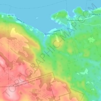
Name: Queensport topographic map, elevation, terrain.
Average elevation: 58 m
Minimum elevation: 0 m
Maximum elevation: 152 m
Thank you for supporting this site ❤️
Make a donation
Make a donation
Other topographic maps
Click on a map to view its topography, its elevation and its terrain.
Larry's River
Canada > Nova Scotia > Guysborough District Municipality > Larrys River
Average elevation: 5 m
Shingle Lake
Canada > Nova Scotia > Guysborough District Municipality > Forest Hill
Average elevation: 124 m
Clam Harbour Beach
Canada > Nova Scotia > Guysborough District Municipality > Manchester
Average elevation: 15 m