
Thank you for supporting this site ❤️
Make a donation
Make a donation
Blackville topographic map
Click on the map to display elevation.
Thank you for supporting this site ❤️
Make a donation
Make a donation
About this map
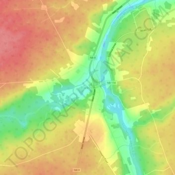
Name: Blackville topographic map, elevation, terrain.
Average elevation: 45 m
Minimum elevation: -3 m
Maximum elevation: 78 m
Thank you for supporting this site ❤️
Make a donation
Make a donation
Other topographic maps
Click on a map to view its topography, its elevation and its terrain.
White Rapids
Canada > New Brunswick > Rural Community of Miramichi River Valley > Blackville Parish
Average elevation: 40 m