
Make a donation
Khyber Pakhtunkhwa topographic map
Click on the map to display elevation.
Make a donation
Khyber Pakhtunkhwa
Most precipitation falls as thunderstorms or snow during winter and spring, so that the climate at the lowest elevations is classed as Mediterranean (Csa), continental Mediterranean (Dsa) or semi-arid (BSk). Summers are extremely dry in the north of Chitral district and receive only a little rain in the south around Drosh.
Make a donation
About this map
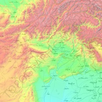
Name: Khyber Pakhtunkhwa topographic map, elevation, terrain.
Location: Khyber Pakhtunkhwa, Pakistan (31.06680 69.23780 36.90879 74.11646)
Average elevation: 1,902 m
Minimum elevation: 146 m
Maximum elevation: 7,597 m
Make a donation
Other topographic maps
Click on a map to view its topography, its elevation and its terrain.
Gwādar
Pakistan > Balochistan > Gwadar District
Gwadar is situated on the southwestern Arabian Sea coast of Pakistan in Gwadar District of Balochistan province. Like Ormara further east, Gwadar is situated on a natural hammerhead-shaped tombolo peninsula forming two almost perfect, but naturally curved, semicircular bays on either side. The city is situated…
Average elevation: 6 m
Make a donation
Islamabad
Pakistan > Islamabad Capital Territory
Islamabad is located at 33°26′N 73°02′E / 33.43°N 73.04°E / 33.43; 73.04 at the northern edge of the Pothohar Plateau and at the foot of the Margalla Hills in Islamabad Capital Territory. Its elevation is 540 metres (1,770 ft). The modern capital and the ancient Gakhar city of Rawalpindi form…
Average elevation: 666 m