
Khyber Pakhtunkhwa topographic map
Interactive map
Click on the map to display elevation.
Khyber Pakhtunkhwa
Most precipitation falls as thunderstorms or snow during winter and spring, so that the climate at the lowest elevations is classed as Mediterranean (Csa), continental Mediterranean (Dsa) or semi-arid (BSk). Summers are extremely dry in the north of Chitral district and receive only a little rain in the south around Drosh.
About this map
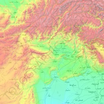
Name: Khyber Pakhtunkhwa topographic map, elevation, terrain.
Location: Khyber Pakhtunkhwa, Pakistan (31.06680 69.23780 36.90879 74.11646)
Average elevation: 1,902 m
Minimum elevation: 146 m
Maximum elevation: 7,597 m
Other topographic maps
Click on a map to view its topography, its elevation and its terrain.
Gwādar
Pakistan > Balochistan > Gwadar District
Gwadar is situated on the southwestern Arabian Sea coast of Pakistan in Gwadar District of Balochistan province. Like Ormara further east, Gwadar is situated on a natural hammerhead-shaped tombolo peninsula forming two almost perfect, but naturally curved, semicircular bays on either side. The city is situated…
Average elevation: 6 m
Islamabad Capital Territory
The temperatures range from 13 °C (55 °F) in January to 38 °C (100 °F) in June. The hottest month is June, where average highs routinely exceed 38 °C (100.4 °F), while the coolest month is January. The highest recorded temperature was 46.6 °C (115.9 °F) on 23 June 2005 while the lowest temperature was…
Average elevation: 697 m
Karachi
Karachi lies very close to a major fault line, where the Indian tectonic plate meets the Arabian tectonic plate. Within the city of Karachi are two small ranges: the Khasa Hills and Mulri Hills, which lie in the northwest and act as a barrier between North Nazimabad and Orangi. Karachi's hills are barren and…
Average elevation: 89 m
Khyber Pakhtunkhwa
Most precipitation falls as thunderstorms or snow during winter and spring, so that the climate at the lowest elevations is classed as Mediterranean (Csa), continental Mediterranean (Dsa) or semi-arid (BSk). Summers are extremely dry in the north of Chitral district and receive only a little rain in the south…
Average elevation: 2,135 m