Geolocate

Sindh topographic map

Interactive map

Click on the map to display elevation.

About this map

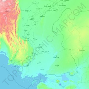
Name: Sindh topographic map, elevation, terrain.

Location: Sindh, Pakistan (23.43420 66.28623 28.49564 71.12577)

Average elevation: 173 m

Minimum elevation: -5 m

Maximum elevation: 2,662 m

Other topographic maps

Click on a map to view its topography, its elevation and its terrain.

Gwādar

Pakistan > Balochistan > Gwadar District

Gwadar is situated on the southwestern Arabian Sea coast of Pakistan in Gwadar District of Balochistan province. Like Ormara further east, Gwadar is situated on a natural hammerhead-shaped tombolo peninsula forming two almost perfect, but naturally curved, semicircular bays on either side. The city is situated…

Average elevation: 6 m

Lahore

Pakistan > Punjab

Average elevation: 211 m

Gharo

Pakistan > Sindh > Dadu District

Average elevation: 47 m

Mominabad Town

Pakistan > Sindh > Karachi West District

Average elevation: 59 m

Azad Kashmir

Pakistan

Average elevation: 1,709 m

Khyber Pakhtunkhwa

Pakistan

Most precipitation falls as thunderstorms or snow during winter and spring, so that the climate at the lowest elevations is classed as Mediterranean (Csa), continental Mediterranean (Dsa) or semi-arid (BSk). Summers are extremely dry in the north of Chitral district and receive only a little rain in the south…

Average elevation: 1,902 m

Islamabad Capital Territory

Pakistan

The temperatures range from 13 °C (55 °F) in January to 38 °C (100 °F) in June. The hottest month is June, where average highs routinely exceed 38 °C (100.4 °F), while the coolest month is January. The highest recorded temperature was 46.6 °C (115.9 °F) on 23 June 2005 while the lowest temperature was…

Average elevation: 697 m

Bhimber

Pakistan

Average elevation: 378 m

Karachi

Pakistan > Sindh > Karachi

Karachi lies very close to a major fault line, where the Indian tectonic plate meets the Arabian tectonic plate. Within the city of Karachi are two small ranges: the Khasa Hills and Mulri Hills, which lie in the northwest and act as a barrier between North Nazimabad and Orangi. Karachi's hills are barren and…

Average elevation: 89 m

Korangi

Pakistan > Sindh > Karachi

Average elevation: 9 m

Lahore District

Pakistan > Punjab

Average elevation: 209 m

Baltoro Glacier

Pakistan > Gilgit-Baltistan

Average elevation: 5,349 m

Gasherbrum I

Pakistan > Gilgit-Baltistan

Average elevation: 7,177 m

K2

Pakistan > Gilgit-Baltistan

Average elevation: 7,490 m

Sangemarmur

Pakistan > Gilgit-Baltistan

Average elevation: 5,955 m

Multān District

Pakistan > Punjab

Average elevation: 129 m

Gasherbrum IV

Pakistan > Gilgit-Baltistan

Average elevation: 6,806 m

Laila Peak

Pakistan > Gilgit-Baltistan

Average elevation: 5,066 m

Saltoro Kangri

Pakistan > Gilgit-Baltistan

Average elevation: 6,652 m

Khyber Pakhtunkhwa

Pakistan > Khyber Pakhtunkhwa

Most precipitation falls as thunderstorms or snow during winter and spring, so that the climate at the lowest elevations is classed as Mediterranean (Csa), continental Mediterranean (Dsa) or semi-arid (BSk). Summers are extremely dry in the north of Chitral district and receive only a little rain in the south…

Average elevation: 2,135 m

Malubiting

Pakistan > Gilgit-Baltistan

Average elevation: 6,584 m

Trango Glacier

Pakistan > Gilgit-Baltistan

Average elevation: 5,284 m

Kunyang Chhish

Pakistan > Gilgit-Baltistan

Average elevation: 6,837 m

Haramosh

Pakistan > Gilgit-Baltistan

Average elevation: 6,476 m

Panmah Glacier

Pakistan > Gilgit-Baltistan

Average elevation: 4,966 m

Quetta

Pakistan > Balochistan > Quetta

Average elevation: 1,970 m

Diran

Pakistan > Gilgit-Baltistan > Gilgit

Average elevation: 6,311 m