
Make a donation
Bhimber topographic map
Click on the map to display elevation.
Make a donation
About this map
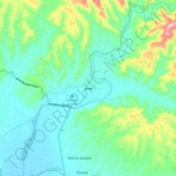
Name: Bhimber topographic map, elevation, terrain.
Location: Bhimber, Bhimber District, Pakistan (32.93406 74.03385 33.01406 74.11385)
Average elevation: 378 m
Minimum elevation: 306 m
Maximum elevation: 607 m
Make a donation
Other topographic maps
Click on a map to view its topography, its elevation and its terrain.
Islamabad Capital Territory
The temperatures range from 13 °C (55 °F) in January to 38 °C (100 °F) in June. The hottest month is June, where average highs routinely exceed 38 °C (100.4 °F), while the coolest month is January. The highest recorded temperature was 46.6 °C (115.9 °F) on 23 June 2005 while the lowest temperature was…
Average elevation: 697 m
Make a donation
Khyber Pakhtunkhwa
Most precipitation falls as thunderstorms or snow during winter and spring, so that the climate at the lowest elevations is classed as Mediterranean (Csa), continental Mediterranean (Dsa) or semi-arid (BSk). Summers are extremely dry in the north of Chitral district and receive only a little rain in the south…
Average elevation: 1,902 m