
Agra topographic map
Interactive map
Click on the map to display elevation.
About this map
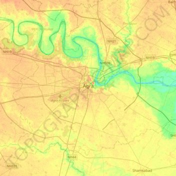
Name: Agra topographic map, elevation, terrain.
Location: Agra, Uttar Pradesh, India (27.04720 77.85178 27.29598 78.22094)
Average elevation: 166 m
Minimum elevation: 143 m
Maximum elevation: 181 m
The region around Agra consists almost entirely of a level plain, with hills in the extreme southwest. The rivers in the region include Yamuna and Chambal. The region is also watered by the Agra Canal. Millet, barley, wheat and cotton are among the crops grown in the surrounding countryside. Both Rabi and Kharif crops are cultivated. The deserted city of Fatehpur Sikri is about 40 km southwest of Agra. The sandstone hills near Fatehpur Sikri and on the south-eastern borders of the district are offshoots from the Vindhya range of Central India. Agra is about 210 km away from the National capital of New Delhi(via Yamuna Expressway), about 336 km from state capital Lucknow(via Agra-Lucknow Expressway), and about 227 km from Kanpur(via Agra-Lucknow Expressway). The city has an average elevation of 170 metres above sea level.
Other topographic maps
Click on a map to view its topography, its elevation and its terrain.
Lucknow
India > Uttar Pradesh > Lucknow
Lucknow, Lucknow District, Uttar Pradesh, 226027, India
Average elevation: 120 m
Prayagraj
India > Uttar Pradesh > Prayagraj
Prayagraj, Prayagraj District, Uttar Pradesh, 211001, India
Average elevation: 91 m
Varanasi
India > Uttar Pradesh > Sadar
Varanasi, Sadar, Varanasi District, Uttar Pradesh, 221001, India
Average elevation: 77 m
Chandauli
Chandauli, Chandauli District, Uttar Pradesh, India
Average elevation: 75 m
Greater Noida
India > Uttar Pradesh > Gautam Buddha Nagar
Greater Noida, Gautam Buddha Nagar, Uttar Pradesh, 201310, India
Average elevation: 203 m
Mat
India > Uttar Pradesh > Mathura District
Mat, Mathura District, Uttar Pradesh, India
Average elevation: 182 m
Balrampur
Balrampur, Balrampur District, Uttar Pradesh, India
Average elevation: 136 m
Barhalganj
India > Uttar Pradesh > Gola
Barhalganj, Gola, Gorakhpur District, Uttar Pradesh, 273402, India
Average elevation: 72 m
G B Nagar
India > Uttar Pradesh > Ghaziabad
G B Nagar, Raghunathpuri, Ghaziabad, Ghaziabad District, Uttar Pradesh, 201009, India
Average elevation: 204 m
Giror
India > Uttar Pradesh > Mainpuri
Giror, Mainpuri, Mainpuri District, Uttar Pradesh, 205121, India
Average elevation: 160 m
Thakurdwara
Thakurdwara, Moradabad District, Uttar Pradesh, India
Average elevation: 215 m
Bhira
India > Uttar Pradesh > Palia
Bhira, Palia, Lakhimpur Kheri District, Uttar Pradesh, India
Average elevation: 159 m
Kanpur
India > Uttar Pradesh > Kanpur > Kanpur
Kanpur, Kanpur Nagar, Uttar Pradesh, 208012, India
Average elevation: 124 m
Basti
Basti, Siddharthnagar District, Uttar Pradesh, 272207, India
Average elevation: 200 m
Kunda
India > Uttar Pradesh > Pratapgarh District
Kunda, Pratapgarh District, Uttar Pradesh, India
Average elevation: 102 m
Jansath
Jansath, Muzaffarnagar District, Uttar Pradesh, India
Average elevation: 238 m
Vikram Nagar
India > Uttar Pradesh > Lucknow
Vikram Nagar, Lucknow, Lucknow District, Uttar Pradesh, 226008, India
Average elevation: 124 m
Barabanki
India > Uttar Pradesh > Nawabganj
Barabanki, Nawabganj, Barabanki District, Uttar Pradesh, 225001, India
Average elevation: 118 m
Meerut
Meerut, Meerut District, Uttar Pradesh, 250003, India
Average elevation: 225 m
Badaun
India > Uttar Pradesh > Budaun
Badaun, Budaun, Badaun District, Uttar Pradesh, 243600, India
Average elevation: 168 m
Binauli
India > Uttar Pradesh > Baraut
Binauli, Baraut, Baghpat District, Uttar Pradesh, 250345, India
Average elevation: 228 m
Naini
India > Uttar Pradesh > Karchhana
Naini, Karchhana, Prayagraj District, Uttar Pradesh, 211008, India
Average elevation: 89 m
Hamirpur
India > Uttar Pradesh > Hamirpur District
Hamirpur, Hamirpur District, Uttar Pradesh, India
Average elevation: 121 m
Rudrapur
Rudrapur, Deoria District, Uttar Pradesh, 274204, India
Average elevation: 73 m
Moti Nagar
India > Uttar Pradesh > Lucknow > Lucknow
Moti Nagar, Lucknow, Lucknow District, Uttar Pradesh, 226004, India
Average elevation: 124 m
Dewal
India > Uttar Pradesh > Zamania
Dewal, Zamania, Ghazipur District, Uttar Pradesh, India
Average elevation: 66 m
Bharuwa Sumerpur
India > Uttar Pradesh > Hamirpur District
Bharuwa Sumerpur, Hamirpur, Hamirpur District, Uttar Pradesh, 210502, India
Average elevation: 121 m
Shafipur
India > Uttar Pradesh > Gautam Buddha Nagar
Shafipur, Gautam Buddha Nagar, Gautam Buddha Nagar District, Uttar Pradesh, 201310, India
Average elevation: 196 m
Peer Bahoda
India > Uttar Pradesh > Bareilly
Peer Bahoda, Bareilly, Bareilly District, Uttar Pradesh, 243202, India
Average elevation: 174 m
Dankaur
India > Uttar Pradesh > Gautam Buddha Nagar
Dankaur, Gautam Buddha Nagar, Gautam Buddha Nagar District, Uttar Pradesh, 203200, India
Average elevation: 197 m
Mohanlalganj
Mohanlalganj, Lucknow District, Uttar Pradesh, India
Average elevation: 117 m
Govardhan
India > Uttar Pradesh > Mathura
Govardhan, Mathura, Agra division, Uttar Pradesh, 281502, India
Average elevation: 181 m
Baraut
India > Uttar Pradesh > Baraut
Baraut, Baghpat, Uttar Pradesh, 250611, India
Average elevation: 227 m
Saharanpur
Saharanpur, Saharanpur District, Uttar Pradesh, India
Average elevation: 287 m
Devgarh
India > Uttar Pradesh > Lalitpur Tehsil
Devgarh, Lalitpur Tehsil, Lalitpur, Uttar Pradesh, India
Average elevation: 384 m
Sarnath
India > Uttar Pradesh > Sadar
Sarnath, Sadar, Varanasi, Uttar Pradesh, 221007, India
Average elevation: 78 m
Madhuban
India > Uttar Pradesh > Madhuban
Madhuban, Mau, Uttar Pradesh, 274404, India
Average elevation: 70 m
Modinagar
India > Uttar Pradesh > Ghaziabad District
Modinagar, Ghaziabad District, Uttar Pradesh, 201204, India
Average elevation: 220 m
semra
India > Uttar Pradesh > Sahjanwa
semra, Sahjanwa, Gorakhpur, Uttar Pradesh, India
Average elevation: 79 m