
Whakatāne District topographic map
Interactive map
Click on the map to display elevation.
About this map
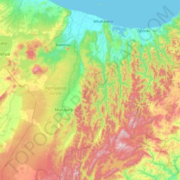
Name: Whakatāne District topographic map, elevation, terrain.
Location: Whakatāne District, Bay of Plenty, Nouvelle-Zélande (-38.85596 176.47628 -37.82942 177.23950)
Average elevation: 416 m
Minimum elevation: 0 m
Maximum elevation: 1,365 m
Other topographic maps
Click on a map to view its topography, its elevation and its terrain.
Whakamarama
Nouvelle-Zélande > Bay of Plenty
Whakamarama, Western Bay of Plenty District, Bay of Plenty, 3179, Nouvelle-Zélande
Average elevation: 266 m
Tauranga City
Nouvelle-Zélande > Bay of Plenty
Tauranga City, Bay of Plenty, Nouvelle-Zélande
Average elevation: 55 m
Rotorua Lakes District
Nouvelle-Zélande > Bay of Plenty
Rotorua Lakes District, Bay of Plenty, Nouvelle-Zélande
Average elevation: 404 m
Wairere Falls
Nouvelle-Zélande > Bay of Plenty > Rotorua
Wairere Falls, Rotorua, Rotorua District, Bay of Plenty, Nouvelle-Zélande
Average elevation: 451 m
Mayor Island / Tuhua
Nouvelle-Zélande > Bay of Plenty > Tauranga
Mayor Island / Tuhua, Tauranga, Bay of Plenty, Nouvelle-Zélande
Average elevation: 71 m
Lake Ōkataina
Nouvelle-Zélande > Bay of Plenty > Ruato
Lake Ōkataina, Eastern Okataina Walkway, Ruato, Rotorua District, Bay of Plenty, Nouvelle-Zélande
Average elevation: 440 m
Rotorua
Nouvelle-Zélande > Bay of Plenty > Rotorua Lakes District
Rotorua, Rotorua Lakes District, Bay of Plenty, 3010, Nouvelle-Zélande
Average elevation: 435 m