Geolocate

Klaten topographic map

Interactive map

Click on the map to display elevation.

About this map

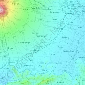
Name: Klaten topographic map, elevation, terrain.

Location: Klaten, Central Java, Indonesia (-7.80833 110.44620 -7.54096 110.79975)

Average elevation: 284 m

Minimum elevation: 74 m

Maximum elevation: 2,657 m

Other topographic maps

Click on a map to view its topography, its elevation and its terrain.

kasimpar

Indonesia > Central Java > Banjarnegara

Average elevation: 1,499 m

Tengger

Indonesia > Central Java > Blora

Average elevation: 91 m

Pati

Indonesia > Central Java > Pati

Average elevation: 101 m

Kertasari

Indonesia > Central Java > Tegal

Average elevation: 13 m

Ungaran

Indonesia > Central Java > Semarang

Average elevation: 357 m

Purwokerto

Indonesia > Central Java > Purwokerto

Average elevation: 277 m

Popongan

Indonesia > Central Java > Popongan

Average elevation: 34 m

Limpung

Indonesia > Central Java > Limpung

Average elevation: 272 m

Jatinom

Indonesia > Central Java > Jatinom

Average elevation: 333 m