
Make a donation
Thar Desert topographic map
Click on the map to display elevation.
Make a donation
About this map
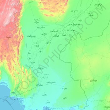
Name: Thar Desert topographic map, elevation, terrain.
Location: Thar Desert, Pakistan (24.16837 68.93371 29.67970 72.99007)
Average elevation: 278 m
Minimum elevation: -1 m
Maximum elevation: 3,165 m
Make a donation
Other topographic maps
Click on a map to view its topography, its elevation and its terrain.
Karachi
Pakistan > Sindh > Karachi South District > Saddar Town
Karachi lies very close to a major fault line, where the Indian tectonic plate meets the Arabian tectonic plate. Within the city of Karachi are two small ranges: the Khasa Hills and Mulri Hills, which lie in the northwest and act as a barrier between North Nazimabad and Orangi. Karachi's hills are barren and…
Average elevation: 20 m
Islamabad
Pakistan > Islamabad Capital Territory
Islamabad is located at 33°26′N 73°02′E / 33.43°N 73.04°E / 33.43; 73.04 at the northern edge of the Pothohar Plateau and at the foot of the Margalla Hills in Islamabad Capital Territory. Its elevation is 540 metres (1,770 ft). The modern capital and the ancient Gakhar city of Rawalpindi form…
Average elevation: 666 m
Sindh
There is no evidence of large palaces or large tombs for the elite. The grand and presumably holy site might have been the great bath, which is built upon an artificially created elevation. This civilization collapsed around 1700 BC for reasons that are uncertain; the cause is hotly debated and may have been a…
Average elevation: 173 m
Make a donation
Gilgit-Baltistan
Three of the world's longest glaciers outside the polar regions are found in Gilgit-Baltistan: the Biafo Glacier, the Baltoro Glacier, and the Batura Glacier. There are, in addition, several high-altitude lakes in Gilgit-Baltistan.
Average elevation: 3,949 m
Rawalpindi
Pakistan > Punjab > Rawalpindi District > Rawalpindi Cantonment
Rawalpindi features a humid subtropical climate (Köppen: Cwa) with hot and wet summers, a cooler and drier winter. Rawalpindi and its twin city Islamabad, during the year experiences an average of 91 thunderstorms, which is the highest frequency of any plain elevation city in the country. Strong windstorms…
Average elevation: 530 m
Punjab
Punjab's landscape consists mostly consists of fertile alluvial plains of the Indus River and its four major tributaries in Pakistan, the Jhelum, Chenab, Ravi, and Sutlej rivers which traverse Punjab north to south – the fifth of the "five waters" of Punjab, the Beas River, lies exclusively in the Indian…
Average elevation: 623 m
Make a donation
Skardu
Pakistan > Gilgit-Baltistan > Skardu District
Skardu (Balti: སྐར་མདོ་་; Urdu: سکردو, romanized: skardū, pronounced [skərduː]) is a city located in Pakistani-administered Gilgit−Baltistan in the disputed Kashmir region. Skardu serves as the capital of Skardu District and the Baltistan Division. It is situated at an average…
Average elevation: 3,423 m
Khyber Pakhtunkhwa
Most precipitation falls as thunderstorms or snow during winter and spring, so that the climate at the lowest elevations is classed as Mediterranean (Csa), continental Mediterranean (Dsa) or semi-arid (BSk). Summers are extremely dry in the north of Chitral district and receive only a little rain in the south…
Average elevation: 2,135 m
Make a donation
Buner District
Buner's elevation starts at 1200 ft in the South in Totalai and reaches a maximum height of 9,550 ft at the Dosara Peak in the North. The majority of the hills that encircle the Buner District are covered in pine trees. Barandu, Chamla, and Budal are the three principal rivers; the former flows through the…
Average elevation: 953 m
Quetta
Quetta (/ˈkwɛtə/; Urdu: کوئٹہ; [ˈkweːʈə] (listen); Pashto: کوټه) is the tenth most populous city in Pakistan with a population of over 1.1 million. It is situated in south-west of the country close to the International border with Afghanistan. It is the capital of the province of Balochistan…
Average elevation: 1,968 m
K2
Pakistan > Gilgit-Baltistan > Shigar District
K2 is the only 8,000+ metre peak that has never been climbed from its eastern face. Ascents have almost always been made in July and August, which are typically the warmest times of the year; K2's more northern location makes it more susceptible to inclement and colder weather. The peak has now been climbed by…
Average elevation: 7,474 m
Make a donation
Ziarat District
Ziarat (Urdu: ضلع زیارت) is a district in the north of Balochistan province of Pakistan. Ziarat town (situated at an altitude of about 2,400 meters) is the headquarters of the district, the sub-division, and also of the tehsil. The highest peak of Khalifat Hills, at an altitude of 11,400 feet (3,500…
Average elevation: 1,837 m
Make a donation
Lakki Marwat District
The district is a combination of hills and sandy plains. The hilly areas are along the boundaries of the district especially in the east, southeast, southwest and northwest. In the southeast, the Marwat range separates Lakki Marwat from Dera Ismail Khan District while in the east the Karak Niazi range…
Average elevation: 353 m
Usta Muhammad Tehsil
Pakistan > Balochistan > Jafarabad District
Usta Mohammad is in the Kachhi plain basin, with an average altitude of about 55 meters. Annual rainfall is about 90mm, of which 60mm falls in winter (November–May). Winters are cold, and summers are dry and hot.
Average elevation: 53 m
Make a donation
Make a donation
Make a donation
Nanga Parbat
Pakistan > Gilgit-Baltistan > Astore District
To the south, Nanga Parbat has what is often referred to as the highest mountain face in the world: the Rupal Face rises 4,600 m (15,090 ft) above its base. To the north, the complex, somewhat more gently sloped Rakhiot Flank rises 7,000 m (23,000 ft) from the Indus River valley to the summit in just 25 km (16…
Average elevation: 7,086 m
Make a donation
Barkhan District
The landscape of Barkhan consists of plains, valleys and mountains varying in ground elevation ranging from 841 to 2,031 meters above Mean Sea Level (MSL). The district consists of one main valley, called Barkhan, and several smaller valleys, which are separated from the main valley by low ranges of hills…
Average elevation: 1,097 m
Make a donation
Make a donation
Qilla Abdullah District
Kila Abdullah district lies between 30 and 04' to 31–17' North Longitude in the foothills of the Shela Bagh Mountain range. It is bordered by Pishin District in the east, Quetta District in the South and by Afghanistan in the west. The geographical area of the district is 5,264 km2. It is composed of two…
Average elevation: 1,700 m
Make a donation
Panjgur District
Panjgur District covers an area of 16,891 square kilometres (6,522 sq mi) in western Balochistan, sharing an international border with Sistan and Baluchestan province of Iran to the west. This boundary, known as the Goldsmid Line, was formalised as the Perso-Baloch frontier in the nineteenth century and…
Average elevation: 857 m
Make a donation
Sherani District
Many wild plants in the area are used by local communities for traditional medicine, food, animal fodder, fencing, and household needs. At higher elevations, forested areas also include Pinus gerardiana (chilghoza pine), which is valued for its edible nuts and local importance.
Average elevation: 1,312 m
Sibi District
Sibi (Urdu and Balochi: سبی ) is a district in the Balochistan province of Pakistan. The climate and topography of Sibi District are quite varied compared to the other districts of Balochistan. It is also known as the "hotspot" of Pakistan, where the temperatures in the summer exceeded 52.6 °C (126.7 °F).…
Average elevation: 570 m
Make a donation
Abbottabad
Pakistan > Khyber Pakhtunkhwa > Abbottābād District
Abbottabad (/ˈæbətəbɑːd/; Urdu, Hindko: ایبٹ آباد, romanized: aibṭabād, pronounced [ɛːbʈəˈbaːd̪]) is the capital city of Abbottabad District in the Hazara region of eastern Khyber Pakhtunkhwa, Pakistan. It is the 40th largest city in Pakistan and fourth largest in the province of Khyber…
Average elevation: 1,363 m
Bahawalnagar
In 1904 when Nawab Mohammad Bahawal Khan Abbasi IV, who originally ruled over Bahawalpur State visited Rojhanwali the people asked that with His permission they want to rename the city on the name of Nawab, The Nawab allowed them with pleasure and since then the city is named as Bahawalnagar. With the advent…
Average elevation: 158 m
Make a donation
Faisalabad
The soil consists of young stratified silt loam or very fine sand loam which makes the subsoil weak in structure with common kankers at only five feet. The course of the rivers within Faisalabad are winding and often subject to frequent alternations. In the rainy season, the currents are very strong. This…
Average elevation: 184 m
Make a donation
Murree
Pakistan > Punjab > Murree District
Murree (Punjabi, Urdu: مری) is a mountain resort city, located in the Galyat region of the Pir Panjal Range, within the Muree District of Punjab, Pakistan. It forms the outskirts of the Islamabad-Rawalpindi metropolitan area, and is about 30 km (19 mi) northeast of Islamabad. It has average altitude of…
Average elevation: 1,718 m
Make a donation
Hindu Kush
Pakistan > Khyber Pakhtunkhwa > Chitrāl District > Chitral Tehsil
Average elevation: 5,281 m
Make a donation
Make a donation
Islamabad
Pakistan > Islamabad Capital Territory
Islamabad is located at 33°26′N 73°02′E / 33.43°N 73.04°E / 33.43; 73.04 at the northern edge of the Pothohar Plateau and at the foot of the Margalla Hills in Islamabad Capital Territory. Its elevation is 540 metres (1,770 ft). The modern capital and the ancient Gakhar city of Rawalpindi form…
Average elevation: 666 m
Indus River
Pakistan > Gilgit-Baltistan > Kharmang District > Manthokha
In the uppermost, highest part of the Indus River basin there are relatively few genera and species: Diptychus, Ptychobarbus, Schizopyge, Schizopygopsis and Schizothorax snowtrout, Triplophysa loaches, and the catfish Glyptosternon reticulatum. Going downstream these are soon joined by the golden mahseer Tor…
Average elevation: 2,956 m
Make a donation
Gilgit
Pakistan > Gilgit-Baltistan > Gilgit District
Gilgit lacks significant rainfall, averaging in 120 to 240 mm (4.7 to 9.4 in) annually, as monsoon breaks against the southern range of Himalayas. Irrigation for land cultivation is obtained from the rivers, abundant with melting snow water from higher altitudes.
Average elevation: 3,002 m
Make a donation
Bumburait
Pakistan > Khyber Pakhtunkhwa > Chitrāl District > Chitral Tehsil
Average elevation: 2,446 m
Make a donation
K2
Pakistan > Gilgit-Baltistan > Shigar District
Also occasionally known as Mount Godwin-Austen, other nicknames for K2 are The King of Mountains and The Mountaineers' Mountain, as well as The Mountain of Mountains after prominent Italian climber Reinhold Messner titled his book about K2 the same. Although the summit of Everest is at a higher altitude, K2 is…
Average elevation: 7,474 m
Make a donation
Gilgit
Pakistan > Gilgit-Baltistan > Gilgit District
Gilgit lacks significant rainfall, averaging in 120 to 240 mm (4.7 to 9.4 in) annually, as monsoon breaks against the southern range of Himalayas. Irrigation for land cultivation is obtained from the rivers, abundant with melting snow water from higher altitudes.
Average elevation: 3,002 m
Make a donation
Charsadda
Pakistan > Khyber Pakhtunkhwa > Charsadda District
Chārsadda (Pashto: چارسده; pronounce; Urdu: چارسدہ; pronounce) is a town and headquarters of Charsadda District, in the Khyber Pakhtunkhwa province of Pakistan. It is the 85th-largest city of Pakistan, according to 2017 census. Located in the Valley of Peshawar, Charsadda lies about 29 kilometres…
Average elevation: 317 m
Karachi Division
Karachi lies very close to a major fault line, where the Indian tectonic plate meets the Arabian tectonic plate. However, Karachi lies near the western edge of the Indian Plate, on the Indo Gangetic Plain. Within the city of Karachi are two small ranges: the Khasa Hills and Mulri Hills, which lie in the…
Average elevation: 89 m
Mastung District
Mastung District is located in the northwest of Balochistan (Pakistan), covering an area of 3,308 km². It lies south of Quetta District, with elevations between 5,600 feet (1,700 m) to 10,000 feet (3,000 m) above sea level.
Average elevation: 1,617 m
Make a donation