
Make a donation
Victoria topographic map
Click on the map to display elevation.
Make a donation
About this map
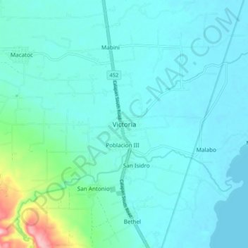
Name: Victoria topographic map, elevation, terrain.
Location: Victoria, Oriental Mindoro, Mimaropa, 5205, Philippines (13.13338 121.23877 13.21338 121.31877)
Average elevation: 28 m
Minimum elevation: 2 m
Maximum elevation: 192 m
Make a donation
Other topographic maps
Click on a map to view its topography, its elevation and its terrain.
Make a donation
Make a donation
Calapan
Philippines > Oriental Mindoro
The overall land characteristic is a wide plain with rivers, interspersed with wetlands at the seacoast periphery. The highest elevation is 187 m (614 ft) above sea level at Bulusan Hill, a 6-kilometre (3.7 mi) long landform east of the city, which interrupts the mostly flat terrain north-east of the…
Average elevation: 12 m
Make a donation
Naujan Lake
Philippines > Oriental Mindoro > Malabo
Mount Naujan, elevation 1,380 feet (420 m) and one of the inactive volcanoes of the country, is situated northeast of the geographic center of the lake. Several thermal springs and solfataras are reported to exist on the eastern border of the Naujan Lake.
Average elevation: 46 m
Make a donation
Calapan
Philippines > Oriental Mindoro
The overall land characteristic is a wide plain with rivers, interspersed with wetlands at the seacoast periphery. The highest elevation is 187 m (614 ft) above sea level at Bulusan Hill, a 6-kilometre (3.7 mi) long landform east of the city, which interrupts the mostly flat terrain north-east of the…
Average elevation: 12 m
San Teodoro
Philippines > Oriental Mindoro
Lt. Hutchins saw that the topographic location of Subaan proper was not suitable for future municipal site expansion. The place was surrounded by nipa swamps and marshland, and the shores were muddy and rocky. He asked Pres. Juan Rojas if they could find a broader place for the town site. The president…
Average elevation: 578 m
Make a donation