
Thank you for supporting this site ❤️
Make a donation
Make a donation
Lalud topographic map
Click on the map to display elevation.
Thank you for supporting this site ❤️
Make a donation
Make a donation
About this map
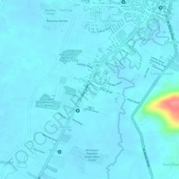
Name: Lalud topographic map, elevation, terrain.
Location: Lalud, Calapan, Oriental Mindoro, Mimaropa, Philippines (13.39506 121.16230 13.40401 121.17815)
Average elevation: 8 m
Minimum elevation: 1 m
Maximum elevation: 85 m
Thank you for supporting this site ❤️
Make a donation
Make a donation
Other topographic maps
Click on a map to view its topography, its elevation and its terrain.
Thank you for supporting this site ❤️
Make a donation
Make a donation
Thank you for supporting this site ❤️
Make a donation
Make a donation
Thank you for supporting this site ❤️
Make a donation
Make a donation
Thank you for supporting this site ❤️
Make a donation
Make a donation