
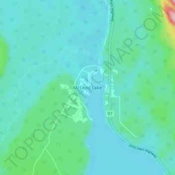
McLeod Lake topographic map
Interactive map
Click on the map to display elevation.
About this map
Name: McLeod Lake topographic map, elevation, terrain.
Average elevation: 701 m
Minimum elevation: 669 m
Maximum elevation: 894 m
A point in the marshes on its southern shore of nearby Summit Lake marks the low point of the divide between the drainages of the Fraser and Peace Rivers, As such it is significant as the prominence col between all points south in the Rockies and beyond and their "parent" summits in northern BC and Alaska. Summit Lake col, at 710 m (2,330 ft) in elevation, is the low point on the mountain spine of the Americas that connects Pico de Orizaba (5,640 m (18,500 ft)) in Mexico with its next-higher "parent" peak, Mount Logan (5,959 m (19,551 ft)).
Other topographic maps
Click on a map to view its topography, its elevation and its terrain.
Crooked River
Canada > British Columbia > Regional District of Fraser-Fort George > Area G (Crooked River/Parsnip)
Crooked River, Area G (Crooked River/Parsnip), Regional District of Fraser-Fort George, British Columbia, Canada
Average elevation: 749 m
Carp Lake
Canada > British Columbia > Regional District of Fraser-Fort George > Area G (Crooked River/Parsnip)
Carp Lake, Area G (Crooked River/Parsnip), Regional District of Fraser-Fort George, British Columbia, Canada
Average elevation: 865 m
Bear Lake
Canada > British Columbia > Regional District of Fraser-Fort George > Area G (Crooked River/Parsnip)
Bear Lake, Area G (Crooked River/Parsnip), Regional District of Fraser-Fort George, British Columbia, V0J 3G0, Canada
Average elevation: 726 m
Tacheeda Lakes
Canada > British Columbia > Regional District of Fraser-Fort George > Area G (Crooked River/Parsnip)
Tacheeda Lakes, Area G (Crooked River/Parsnip), Regional District of Fraser-Fort George, British Columbia, Canada
Average elevation: 875 m
Davie Lake
Canada > British Columbia > Regional District of Fraser-Fort George > Area G (Crooked River/Parsnip)
Davie Lake, Area G (Crooked River/Parsnip), Regional District of Fraser-Fort George, British Columbia, Canada
Average elevation: 718 m
Mugaha Marsh
Canada > British Columbia > Regional District of Fraser-Fort George > Area G (Crooked River/Parsnip)
Mugaha Marsh, Area G (Crooked River/Parsnip), Regional District of Fraser-Fort George, British Columbia, Canada
Average elevation: 681 m