
Chennai topographic map
Interactive map
Click on the map to display elevation.
About this map
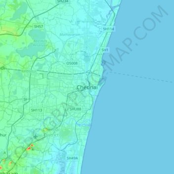
Name: Chennai topographic map, elevation, terrain.
Location: Chennai, Chennai District, Tamil Nadu, 600001, India (12.92369 80.11019 13.24369 80.43019)
Average elevation: 7 m
Minimum elevation: -2 m
Maximum elevation: 142 m
Chennai is located on the south–eastern coast of India in the north–eastern part of Tamil Nadu on a flat coastal plain known as the Eastern Coastal Plains. Its average elevation is around 6.7 metres (22 ft), and its highest point is 60 m (200 ft). Chennai is 2,184 kilometres (1,357 mi) south of Delhi, 1,337 kilometres (831 mi) southeast of Mumbai, and 1,707 kilometres (1,061 mi) southwest of Kolkata by road. Two major rivers flow through Chennai, the Cooum River (or Koovam) through the centre and the Adyar River to the south. A third river, the Kortalaiyar, travels through the northern fringes of the city before draining into the Bay of Bengal, at Ennore. The estuary of this river is heavily polluted with effluents released by the industries in the region. Adyar and Cooum rivers are heavily polluted with effluents and waste from domestic and commercial sources, the Coumm being so heavily polluted it is regarded as the city's eyesore. A protected estuary on the Adyar forms a natural habitat for several species of birds and animals. The Buckingham Canal, 4 km (2.5 mi) inland, runs parallel to the coast, linking the two rivers. The Otteri Nullah, an east–west stream, runs through north Chennai and meets the Buckingham Canal at Basin Bridge. Several lakes of varying size are located on the western fringes of the city. Some areas of the city have the problem of excess iron content in groundwater.
Other topographic maps
Click on a map to view its topography, its elevation and its terrain.
Avalpoondurai
India > Tamil Nadu > Modakkurichi
Avalpoondurai, Modakkurichi, Erode District, Tamil Nadu, 638115, India
Average elevation: 218 m
Ettimadai
India > Tamil Nadu > Coimbatore South
Ettimadai, Coimbatore South, Coimbatore District, Tamil Nadu, 641112, India
Average elevation: 315 m
Erumad
India > Tamil Nadu > Panthalur
Erumad, Panthalur, The Nilgiris District, Tamil Nadu, 643239, India
Average elevation: 875 m
Thuneri
India > Tamil Nadu > Udhagamandalam
Thuneri, Udhagamandalam, The Nilgiris District, Tamil Nadu, 643402, India
Average elevation: 1,932 m
Madathukulam
Madathukulam, Tiruppur District, Tamil Nadu, India
Average elevation: 328 m
Mettupalayam
Mettupalayam, Coimbatore District, Tamil Nadu, India
Average elevation: 861 m
Anaimalai
India > Tamil Nadu > Pollachi
Anaimalai, Pollachi, Coimbatore District, Tamil Nadu, 642104, India
Average elevation: 262 m
Sathyamangalam
Sathyamangalam, Erode District, Tamil Nadu, India
Average elevation: 584 m
Udumalaipettai
Udumalaipettai, Tiruppur District, Tamil Nadu, India
Average elevation: 816 m
Chennimalai
India > Tamil Nadu > Perundurai
Chennimalai, Perundurai, Erode District, Tamil Nadu, 638051, India
Average elevation: 267 m
Coonoor
Coonoor, The Nilgiris District, Tamil Nadu, India
Average elevation: 1,460 m
Mulli
India > Tamil Nadu > Ramanathapuram
Mulli, Ramanathapuram, Ramanathapuram District, Tamil Nadu, India
Average elevation: 0 m
Tiruchirappalli
India > Tamil Nadu > Tiruchchirāppalli
Tiruchirappalli, Tiruchchirāppalli, Tiruchirappalli District, Tamil Nadu, India
Average elevation: 78 m
Trichy Corporation Limits
India > Tamil Nadu > Trichy Corporation Limits
Trichy Corporation Limits, Tiruchirappalli, Tiruchchirappalli district, Tamil Nadu, India
Average elevation: 75 m
Avadi
India > Tamil Nadu > Poonamallee
Avadi, Poonamallee, Thiruvallur District, Tamil Nadu, 600054, India
Average elevation: 23 m
St.Thomas Mount-Pallavaram Cantonment Board
India > Tamil Nadu > Alandur > St.Thomas Mount-Pallavaram Cantonment Board
St.Thomas Mount-Pallavaram Cantonment Board, Alandur, Tamil Nadu, 600016, India
Average elevation: 13 m
Bagalur
India > Tamil Nadu > Hosur > Bagalur
Bagalur, Hosur, Krishnagiri District, Tamil Nadu, 635103, India
Average elevation: 853 m
Poonamallee
India > Tamil Nadu > Poonamallee
Poonamallee, Thiruvallur District, Tamil Nadu, India
Average elevation: 29 m
Pallavaram
India > Tamil Nadu > Pallavaram
Pallavaram, Chengalpattu District, Tamil Nadu, India
Average elevation: 21 m
Tambaram
India > Tamil Nadu > Tambaram
Tambaram, Chengalpattu District, Tamil Nadu, 600045, India
Average elevation: 25 m
Chennai
India > Tamil Nadu > Chennai
Chennai, Chennai district, Tamil Nadu, India
Average elevation: 7 m
Hosur
India > Tamil Nadu > Hosur
Hosur, Krishnagiri, Tamil Nadu, 635109, India
Average elevation: 859 m
Salem
India > Tamil Nadu > Salem
Salem, Salem district, Tamil Nadu, 636007, India
Average elevation: 429 m
Marina Beach (மறீனா கடல்கரை)
India > Tamil Nadu > Chennai
Marina Beach (மறீனா கடல்கரை), Kamarajar Promenade, Chepauk, Ward 114, Zone 9 Teynampet, Chennai, Chennai district, Tamil Nadu, 600005, India
Average elevation: 4 m
Alangayam
India > Tamil Nadu > Alangayam
Alangayam, Vellore district, Tamil Nadu, 635700, India
Average elevation: 516 m
Udhagamandalam
India > Tamil Nadu > Udhagamandalam
Udhagamandalam, The Nilgiris District, Tamil Nadu, 643001, India
Average elevation: 2,234 m
Ward 159
India > Tamil Nadu > Chennai
Ward 159, Zone 12 Alandur, Chennai, Chennai district, Tamil Nadu, India
Average elevation: 13 m
Pudukkottai
Pudukkottai, Pudukkottai District, Tamil Nadu, India
Average elevation: 95 m
Thiruvarur
India > Tamil Nadu > Thiruvarur
Thiruvarur, Nagapattinam district, Tamil Nadu, 610001, India
Average elevation: 10 m
Thanjavur
India > Tamil Nadu > Thanjavur
Thanjavur, Thanjavur District, Tamil Nadu, 613001, India
Average elevation: 49 m
Kumbakonam
India > Tamil Nadu > Kumbakonam
Kumbakonam, Thanjavur district, Tamil Nadu, 612001, India
Average elevation: 27 m
The Nilgiris
The Nilgiris, The Nilgiris district, Tamil Nadu, 643001, India
Average elevation: 679 m
Doddabetta
Doddabetta, The Nilgiris, The Nilgiris district, Tamil Nadu, 643001, India
Average elevation: 2,403 m
Papanasam
India > Tamil Nadu > Papanasam
Papanasam, Thanjavur district, Tamil Nadu, 614200, India
Average elevation: 32 m
Kanchipuram
India > Tamil Nadu > Kanchipuram
Kanchipuram, Kanchipuram district, Tamil Nadu, 631501, India
Average elevation: 82 m
Nanguneri
Nanguneri, Tirunelveli Kattabo, Tamil Nadu, India
Average elevation: 207 m