
Thurston County topographic map
Interactive map
Click on the map to display elevation.
About this map
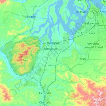
Name: Thurston County topographic map, elevation, terrain.
Location: Thurston County, Washington, United States of America (46.76277 -123.20593 47.19414 -122.20202)
Average elevation: 150 m
Minimum elevation: -2 m
Maximum elevation: 1,156 m
Other topographic maps
Click on a map to view its topography, its elevation and its terrain.
Douglas County
United States of America > Washington
Douglas County, Washington, United States of America
Average elevation: 634 m
Spokane County
United States of America > Washington
Spokane County, Washington, United States of America
Average elevation: 741 m
Yakima County
United States of America > Washington
Yakima County, Washington, United States of America
Average elevation: 879 m
Okanogan County
United States of America > Washington > Okanogan County
Okanogan County, Washington, United States of America
Average elevation: 1,076 m