
Spokane County topographic map
Interactive map
Click on the map to display elevation.
About this map
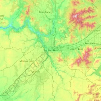
Name: Spokane County topographic map, elevation, terrain.
Location: Spokane County, Washington, United States of America (47.25927 -117.82370 48.04782 -117.03968)
Average elevation: 741 m
Minimum elevation: 418 m
Maximum elevation: 1,787 m
According to the U.S. Census Bureau, the county has a total area of 1,781 square miles (4,610 km2), of which 1,764 square miles (4,570 km2) is land and 17 square miles (44 km2) (0.9%) is water. The lowest point in the county is the Spokane River behind Long Lake Dam (boundary of Stevens County) at 1538 feet (468 m) above sea level. (There is virtually no change in elevation between the dam and the mouth of the Little Spokane River inside Riverside State Park.) The highest point in the county is the summit of Mount Spokane at 5883 feet (1793 m).
Other topographic maps
Click on a map to view its topography, its elevation and its terrain.
Douglas County
United States of America > Washington
Douglas County, Washington, United States of America
Average elevation: 634 m
Yakima County
United States of America > Washington
Yakima County, Washington, United States of America
Average elevation: 879 m
Thurston County
United States of America > Washington
Thurston County, Washington, United States of America
Average elevation: 150 m
Okanogan County
United States of America > Washington > Okanogan County
Okanogan County, Washington, United States of America
Average elevation: 1,076 m