
Narni topographic map
Interactive map
Click on the map to display elevation.
About this map
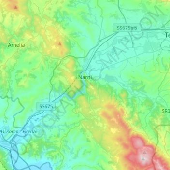
Name: Narni topographic map, elevation, terrain.
Location: Narni, Terni, Umbria, 05035, Italy (42.42158 12.41137 42.60082 12.61466)
Average elevation: 250 m
Minimum elevation: 42 m
Maximum elevation: 1,017 m
Narni (Latin: Narnia) is an ancient hilltown and comune of Umbria, in central Italy, with 19,252 inhabitants (2017). At an altitude of 240 metres (790 ft), it overhangs a narrow gorge of the Nera River in the province of Terni. It is very close to the geographic center of Italy. There is a stone on the exact spot with a sign in multiple languages.
Other topographic maps
Click on a map to view its topography, its elevation and its terrain.