
Milford Sound / Piopiotahi topographic map
Interactive map
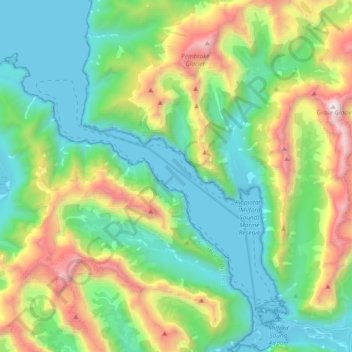
Click on the map to display elevation.
About this map
Name: Milford Sound / Piopiotahi topographic map, elevation, terrain.
Average elevation: 655 m
Minimum elevation: -2 m
Maximum elevation: 2,198 m
Les parois des montagnes qui l'encadrent atteignent par endroits plus de 1 200 mètres de dénivelé et culminent à 1 692 mètres d'altitude au Mitre Peak, 1 517 mètres àThe Elephant et 1 302 à Lion Mountain. La profondeur maximale du fjord dépasse quant à elle les 400 mètres.
Other topographic maps
Click on a map to view its topography, its elevation and its terrain.
Aiguille Rouge
Nouvelle-Zélande > Southland > Southland District > Fiordland Community
Aiguille Rouge, Fiordland Community, Southland District, Southland, Nouvelle-Zélande
Average elevation: 1,058 m
Te Anau
Nouvelle-Zélande > Southland > Southland District > Fiordland Community
Te Anau, Fiordland Community, Southland District, Southland, 9600, Nouvelle-Zélande
Average elevation: 249 m