
Make a donation
Ontario topographic map
Click on the map to display elevation.
Make a donation
Ontario
Ontario's topography is a diverse tapestry shaped by its vast expanse and geological history. The Canadian Shield dominates the northern and central regions, characterized by ancient Precambrian rock formations, rugged terrain, and numerous lakes and rivers. In contrast, the Hudson Bay Lowlands in the far north are flat, swampy areas with sparse vegetation. Southern Ontario features the fertile Great Lakes–St. Lawrence Lowlands, where rolling hills and plains support agriculture and urban development. Prominent features like the Niagara Escarpment add to the province's varied landscape, offering cliffs and slopes that contrast with the surrounding lowlands. The highest elevation point is Ishpatina Ridge in the Temagami area, reaching 693 meters (2,274 feet) above sea level. Overall, Ontario's terrain ranges from flat plains to rolling hills and rugged highlands, reflecting its complex geological past.
Make a donation
About this map
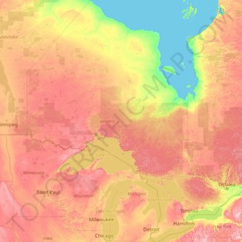
Name: Ontario topographic map, elevation, terrain.
Location: Ontario, Canada (41.67656 -95.15602 56.86135 -74.32011)
Average elevation: 245 m
Minimum elevation: -2 m
Maximum elevation: 996 m
Make a donation
Other topographic maps
Click on a map to view its topography, its elevation and its terrain.
Lund
Canada > British Columbia > qathet Regional District > Area A (Malaspina/Toba)
Average elevation: 57 m
Starkey Hill Conservation Area
Canada > Ontario > Wellington County > Puslinch > Arkell
Average elevation: 348 m
Little Current
Canada > Ontario > Manitoulin District > Northeastern Manitoulin and the Islands
Average elevation: 193 m
Make a donation
Make a donation
Make a donation
Miocene
Canada > British Columbia > Cariboo Regional District > Area F (Horsefly/Likely/150 Mile House)
Average elevation: 1,009 m
Make a donation
Waterton Park
Canada > Alberta > Division No. 3
It is located at the southwestern terminus of Highway 5, approximately 54 kilometres (34 mi) west of the Town of Cardston and 55 kilometres (34 mi) south of the Town of Pincher Creek. This hamlet is north of Glacier National Park in Montana. It has an elevation of 1,280 metres (4,200 ft).
Average elevation: 1,456 m
Make a donation
Make a donation
Eagle Creek
Canada > British Columbia > Cariboo Regional District > Area H (Canim Lake/Forest Grove)
Average elevation: 824 m
Mount Howard-Stowe
Canada > British Columbia > Cariboo Regional District > Area J (West Chilcotin)
Average elevation: 2,125 m