
Ituango topographic map
Interactive map
Click on the map to display elevation.
About this map
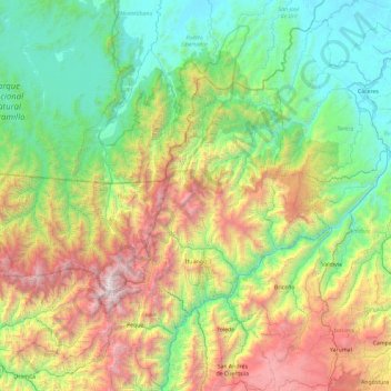
Name: Ituango topographic map, elevation, terrain.
Location: Ituango, Norte, Antioquia, 052050, Kolumbien (7.04445 -76.38093 7.61174 -75.44460)
Average elevation: 1,136 m
Minimum elevation: 67 m
Maximum elevation: 3,714 m
Other topographic maps
Click on a map to view its topography, its elevation and its terrain.
Tierra Adentro
Kolumbien > Antioquia > Tierra Adentro
Tierra Adentro, Bello, Valle de Aburrá, Antioquia, Kolumbien
Average elevation: 1,939 m