
Lochside topographic map
Interactive map
Click on the map to display elevation.
About this map
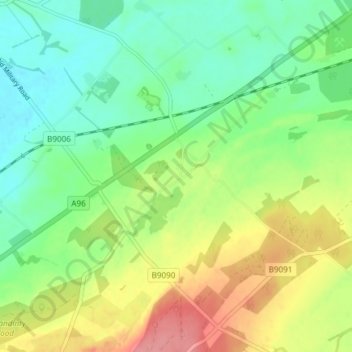
Name: Lochside topographic map, elevation, terrain.
Location: Lochside, Highland, Scotland, IV2 7QR, United Kingdom (57.52666 -4.00623 57.56666 -3.96623)
Average elevation: 36 m
Minimum elevation: 3 m
Maximum elevation: 91 m
Other topographic maps
Click on a map to view its topography, its elevation and its terrain.
Loch Cragaidh
United Kingdom > Scotland > Lochside
Loch Cragaidh, A838, Lochside, Highland, Scotland, IV27 4UJ, United Kingdom
Average elevation: 50 m