
South Holland topographic map
Interactive map
Click on the map to display elevation.
About this map
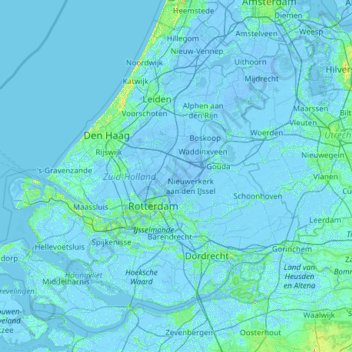
Name: South Holland topographic map, elevation, terrain.
Location: South Holland, Netherlands (51.64378 3.77368 52.33251 5.03142)
Average elevation: 0 m
Minimum elevation: -8 m
Maximum elevation: 35 m
A topographic map of South Holland as of 2013
Other topographic maps
Click on a map to view its topography, its elevation and its terrain.
Klein Haasdal
Netherlands > Limburg > Schimmert
Klein Haasdal, Schimmert, Beekdaelen, Limburg, Netherlands, 6333 DZ, Netherlands
Average elevation: 126 m
Edam
Netherlands > North Holland > Edam-Volendam
Edam, Edam-Volendam, North Holland, Netherlands
Average elevation: -1 m
Scheemda
Netherlands > Groningen > Oldambt
Scheemda, Oldambt, Groningen, Netherlands
Average elevation: 0 m
Katwijk
Netherlands > South Holland > Katwijk
Katwijk, South Holland, Netherlands
Average elevation: 3 m
Camping
Netherlands > Friesland > De Fryske Marren
Camping, De Fryske Marren, Friesland, Netherlands, 8493KN, Netherlands
Average elevation: -1 m
Driehoek
Netherlands > North Brabant > Driehoek
Driehoek, North Brabant, Netherlands, 5691NE, Netherlands
Average elevation: 16 m
Noardburgum
Netherlands > Friesland > Tytsjerksteradiel
Noardburgum, Tytsjerksteradiel, Friesland, Netherlands
Average elevation: 1 m
Eindhoven
Netherlands > North Brabant > Eindhoven
Eindhoven, North Brabant, Netherlands
Average elevation: 20 m
Zoetermeer
Netherlands > South Holland > Zoetermeer
Zoetermeer, South Holland, Netherlands
Average elevation: -3 m
Mill
Netherlands > North Brabant > Mill en Sint Hubert
Mill, Mill en Sint Hubert, North Brabant, Netherlands
Average elevation: 14 m
Apeldoorn
Netherlands > Gelderland > Apeldoorn
Apeldoorn, Gelderland, Netherlands
Average elevation: 23 m