
Make a donation
Carnaza topographic map
Click on the map to display elevation.
Make a donation
Carnaza
The island's topography includes coastal plains, mangrove swamps, lagoons and semi-rounded hills. Its coastal plain constitutes about 9.7% while semi-rounded hills constitute the biggest portion of the island covering about 14.4% of the total area. The mangrove forest has an area of about 10.1 hectares or 5.8% of the island. The highest point was measured at 55 metres (180 feet) above sea level.
Make a donation
About this map
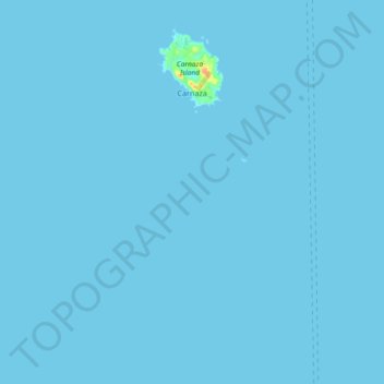
Name: Carnaza topographic map, elevation, terrain.
Location: Carnaza, Cebu, Central Visayas, Philippines (11.44561 124.01932 11.52465 124.11175)
Average elevation: 0 m
Minimum elevation: 0 m
Maximum elevation: 36 m
Make a donation
Other topographic maps
Click on a map to view its topography, its elevation and its terrain.
Make a donation
Make a donation
Make a donation
Carcar
The land is generally level with less than 18% slope comprising 78.7% of the total land area. Areas with slopes ranging from 18 to 50% cover 19.3% of the total land area and those over 50% slope comprise approximately 1.9%. The highest recorded elevation is a little over 660 metres (2,170 ft) above sea level,…
Average elevation: 97 m
Make a donation
Make a donation
Make a donation
Make a donation
Make a donation
Make a donation
Make a donation
Make a donation
Make a donation
Catmon
Catmon's topography is generally mountainous and hilly but patches of flat lands can be found along the coastline and portion of the poblacion. The municipality's climate is of Coronas climate type IV, where rainfall is evenly distributed throughout the year. Mount Capayas (Kapayas) (also known as Tore Peak),…
Average elevation: 67 m
Make a donation
Make a donation
Make a donation
Make a donation
Make a donation
Make a donation
Make a donation
Make a donation
Balamban
Farming is another source of livelihood for residents with corn, crops and vegetables among the important crops. The municipality is also the only source of abaca fibers in Cebu produced in a 260-to-300-hectare (640-to-740-acre) plantation in Mount Manunggal in barangay Magsaysay. With the elevation of 500…
Average elevation: 28 m
Make a donation
Make a donation
Make a donation
Make a donation
Make a donation