Geolocate

Bernina topographic map

Click on the map to display elevation.

About this map

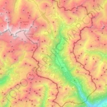
Name: Bernina topographic map, elevation, terrain.

Location: Bernina, Grisons, Switzerland (46.21716 9.95570 46.44272 10.17650)

Average elevation: 2,276 m

Minimum elevation: 429 m

Maximum elevation: 4,000 m

Other topographic maps

Click on a map to view its topography, its elevation and its terrain.

Soladüra

Switzerland > Grisons > Surselva > Vals

Average elevation: 1,806 m

Val Fex

Switzerland > Grisons > Maloja > Sils im Engadin/Segl

Average elevation: 2,512 m

Crastas

Switzerland > Grisons > Maloja > Sils im Engadin/Segl

Average elevation: 2,060 m

Val Bregaglia

Switzerland > Grisons > Maloja > Casaccia

Average elevation: 2,111 m

Haldenstein

Switzerland > Grisons > Plessur > Chur

Before 2017, the municipality was located in the Fünf Dörfer sub-district of the Landquart district, after 2017 it was part of the Plessur Region. It is located north of Chur and on the left bank of the Rhine River. It consists of the haufendorf (an irregular, unplanned and quite closely packed village,…

Average elevation: 826 m

Cantone

Switzerland > Grisons > Bernina

Average elevation: 1,401 m

Ago di Sciora

Switzerland > Grisons > Maloja

Average elevation: 2,637 m

Rongga

Switzerland > Grisons > Plessur > St. Peter

Average elevation: 1,313 m

Jörihorn

Switzerland > Grisons > Prättigau/Davos > Davos

Average elevation: 2,557 m

Soglio

Switzerland > Grisons > Maloja

Average elevation: 1,357 m

Pany

Switzerland > Grisons > Prättigau/Davos > Luzein

Average elevation: 1,236 m

Soladüra

Switzerland > Grisons > Surselva > Vals

Average elevation: 1,806 m

Tenna

Switzerland > Grisons > Surselva > Safiental

Average elevation: 1,617 m

Splügen

Switzerland > Grisons > Viamala > Rheinwald

Average elevation: 1,831 m

Berninapass

Switzerland > Grisons > Maloja > Pontresina

The building of the road began in 1842. Head of engineers was Rudolf Albertini (1821–1896) from Zuoz. The work was finished in 1865 and a hospice at an elevation of 2,307 metres (7,569 ft) was also opened. Since this time the road has been widened several times. Since 1965 it has been open all year round,…

Average elevation: 2,351 m

Li Piani

Switzerland > Grisons > Bernina > Brusio

Average elevation: 1,665 m

Ospiz da Giüglia

Switzerland > Grisons > Albula > Surses

Average elevation: 2,422 m

Jöriseen

Switzerland > Grisons > Prättigau/Davos > Klosters

Average elevation: 2,597 m

Montoi

Switzerland > Grisons > Moësa > San Vittore

Average elevation: 798 m

San Carlo

Switzerland > Grisons > Bernina

Average elevation: 1,497 m

Brienz/Brinzauls

Switzerland > Grisons > Albula > Albula/Alvra

Average elevation: 1,275 m

Cantone

Switzerland > Grisons > Bernina

Average elevation: 1,401 m

Rheinquelle

Switzerland > Grisons > Surselva > Tujetsch

The Swiss Federal Office of Topography and ETH Zürich indicate a point north of Lake Toma and the Rein da Tuma as the source of the Rhine (and also of the Vorderrhein), and as the source of the Hinterrhein a point in the upper valley of the Rheinwald, east of the Rheinwaldhorn.

Average elevation: 2,435 m

Soladüra

Switzerland > Grisons > Surselva > Vals

Average elevation: 1,806 m

Saas im Prättigau

Switzerland > Grisons > Prättigau/Davos

Average elevation: 1,289 m

Caral

Switzerland > Grisons > Prättigau/Davos > Grüsch

Average elevation: 1,412 m

Soglio

Switzerland > Grisons > Maloja

Average elevation: 1,357 m

Piz Kesch

Switzerland > Grisons > Maloja > Zuoz

Average elevation: 2,879 m

Piz Aul

Switzerland > Grisons > Surselva > Vals

Average elevation: 2,557 m

information;Ganda

Switzerland > Grisons > Landquart > Igis

Average elevation: 744 m

Rongga

Switzerland > Grisons > Plessur > St. Peter

Average elevation: 1,313 m

Serneus

Switzerland > Grisons > Prättigau/Davos

Average elevation: 1,367 m

Haldenstein

Switzerland > Grisons > Plessur > Chur

Before 2017, the municipality was located in the Fünf Dörfer sub-district of the Landquart district, after 2017 it was part of the Plessur Region. It is located north of Chur and on the left bank of the Rhine River. It consists of the haufendorf (an irregular, unplanned and quite closely packed village,…

Average elevation: 826 m

Piz Lagalb

Switzerland > Grisons > Maloja > Pontresina

Average elevation: 2,488 m

Aeuja

Switzerland > Grisons > Prättigau/Davos > Klosters

Average elevation: 1,527 m

Farur

Switzerland > Grisons > Plessur > Tschiertschen-Praden

Average elevation: 1,965 m

Piz Cavradi

Switzerland > Grisons > Surselva > Tujetsch

Average elevation: 2,186 m

Mezzaselva

Switzerland > Grisons > Prättigau/Davos > Serneus

Average elevation: 1,391 m

Clavadel

Switzerland > Grisons > Prättigau/Davos > Davos

Average elevation: 1,833 m

Innerarosa

Switzerland > Grisons > Plessur

Average elevation: 2,040 m

Flond

Switzerland > Grisons > Surselva > Obersaxen-Mundaun

Average elevation: 1,126 m

Mathon

Switzerland > Grisons > Viamala > Muntogna da Schons > Donat

Before 2017, the former municipality was located in the Schams sub-district, of the Hinterrhein district, after 2017 it was part of the Viamala Region. The village is a haufendorf (an irregular, unplanned and quite closely packed village, built around a central square) at an elevation of 1,521 m (4,990 ft) in…

Average elevation: 1,520 m

Sottoponte

Switzerland > Grisons > Maloja > Promontogno

Average elevation: 1,302 m

Plaz

Switzerland > Grisons > Albula > Surses > Bivio

Average elevation: 2,085 m

Lake Toma

Switzerland > Grisons > Surselva > Tujetsch

Average elevation: 2,390 m

Tartar

Switzerland > Grisons > Viamala

Average elevation: 984 m

Reichenau

Switzerland > Grisons > Imboden > Tamins

Average elevation: 759 m

Vella

Switzerland > Grisons > Surselva > Lumnezia

Average elevation: 1,318 m

Valle Mesolcina

Switzerland > Grisons > Moësa

Average elevation: 1,675 m

Feldis

Switzerland > Grisons > Viamala > Domleschg

The municipality is located in the Domleschg district. It is a Haufendorf (an irregular, unplanned and quite closely packed village, built around a central square) on a terrace at an elevation of 1,469 m (4,820 ft) on the eastern side of the Hinterrhein valley. Until 1943 Feldis/Veulden was known as Feldis.

Average elevation: 1,186 m

Latsch

Switzerland > Grisons > Albula > Bergün Filisur > Bergün/Bravuogn

Average elevation: 1,731 m

Pian San Giacomo

Switzerland > Grisons > Moësa

Average elevation: 1,568 m

Cavagliola

Switzerland > Grisons > Bernina > Poschiavo

Average elevation: 1,806 m

Cresta

Switzerland > Grisons > Viamala > Ferrera > Ausserferrera

Average elevation: 1,838 m

Crastas

Switzerland > Grisons > Maloja > Sils im Engadin/Segl

Average elevation: 2,060 m

Davosersee

Switzerland > Grisons > Prättigau/Davos > Davos

Average elevation: 1,722 m

Surcuolm

Switzerland > Grisons > Surselva > Obersaxen-Mundaun

Average elevation: 1,311 m

Büel

Switzerland > Grisons > Viamala > Avers

Average elevation: 2,648 m

Raviscé

Switzerland > Grisons > Bernina > San Carlo

Average elevation: 1,529 m

Dusch

Switzerland > Grisons > Viamala > Domleschg > Paspels

Average elevation: 1,042 m

Juf

Switzerland > Grisons > Viamala > Avers

Average elevation: 2,469 m

Vattiz

Switzerland > Grisons > Surselva > Lumnezia

Average elevation: 1,324 m

Vrin

Switzerland > Grisons > Surselva > Lumnezia

Average elevation: 1,698 m

Fürstenaubruck

Switzerland > Grisons > Viamala

Average elevation: 818 m

Ilanz

Switzerland > Grisons > Surselva > Ilanz/Glion

Average elevation: 952 m

Somaino

Switzerland > Grisons > Bernina > San Carlo

Average elevation: 1,512 m

Albulapass

Switzerland > Grisons > Maloja > La Punt Chamues-ch

The Albula Pass is an important axis from central Graubünden to Engadin. It is traversed by a paved road from Thusis to La Punt, via Bergün. It is also traversed by the Albula Railway, although at a lower elevation through the Albula Tunnel (1,820 m), from Thusis to Bever, also via Bergün.

Average elevation: 2,560 m

Splügen Pass

Switzerland > Grisons > Viamala > Rheinwald

Average elevation: 2,243 m

Sevgein

Switzerland > Grisons > Surselva > Ilanz/Glion

Average elevation: 973 m

Juf

Switzerland > Grisons > Viamala > Avers

Average elevation: 2,469 m

Piz Vadret

Switzerland > Grisons > Region Engiadina Bassa/Val Müstair > Zernez

Piz Vadret is a mountain of the Albula Alps, in Graubünden. With an altitude of 3,229 metres above sea level, Piz Vadret is the highest mountain of the Albula Alps north of Piz Kesch. At the base of the north face lies a glacier named Vadret da Grialetsch. The closest locality is Brail, in the Engadin.

Average elevation: 2,824 m

Orden

Switzerland > Grisons > Maloja > Maloja

Average elevation: 1,988 m

Piz Gannaretsch

Switzerland > Grisons > Medel (Lucmagn)

Average elevation: 2,573 m

Lenzerheide

Switzerland > Grisons > Albula > Vaz/Obervaz

Average elevation: 1,723 m

Savognin

Switzerland > Grisons > Albula > Surses

Average elevation: 1,461 m

Pass dal Güglia

Switzerland > Grisons > Surses

Average elevation: 2,443 m

Casaccia

Switzerland > Grisons > Maloja

Casaccia is a village located in the Val Bregaglia, in the Swiss canton of Graubünden. It lies at an altitude of 1,458 metres above sea level, at the southern foot of Piz Lunghin. The village belongs to the municipality of Bregaglia.

Average elevation: 1,929 m

Logiano

Switzerland > Grisons > Moësa > Mesocco > Logiano

Average elevation: 1,336 m

Poschiavo

Switzerland > Grisons > Bernina > Poschiavo > Poschiavo

Average elevation: 1,412 m

Pontresina

Switzerland > Grisons > Maloja > Pontresina > Pontresina

Average elevation: 2,110 m

Tingés

Switzerland > Grisons > Moësa > Soazza

Average elevation: 1,044 m

Lägh dal Lunghin

Switzerland > Grisons > Maloja

Lägh dal Lunghin (German: Lunghinsee) is a lake at an elevation of 2484 m, below the peak of Piz Lunghin, in the Graubünden, Switzerland. It is considered the source of the Inn River.

Average elevation: 2,456 m

Filisur

Switzerland > Grisons > Albula > Bergün Filisur > Filisur

Before 2017, the municipality was located in the Bergün subdistrict of the Albula district, since 2017 it is part of the Albula Region. It consists of the village of Filisur and the hamlet of Jenisberg at an elevation of 1,504 m (4,934 ft).

Average elevation: 1,319 m

Silvaplana

Switzerland > Grisons > Maloja > Silvaplana > Silvaplana

Average elevation: 2,027 m

Sankt Moritz

Switzerland > Grisons > Maloja > Sankt Moritz > Sankt Moritz

Average elevation: 2,185 m

Davos

Switzerland > Grisons > Prättigau/Davos > Davos > Davos

Average elevation: 2,007 m

Valbella

Switzerland > Grisons > Albula > Vaz/Obervaz > Valbella

Average elevation: 1,720 m

Scot

Switzerland > Grisons > Moësa > Mesocco > Spina

Average elevation: 1,572 m

Ringelspitz

Switzerland > Grisons > Imboden > Trin

Average elevation: 2,628 m

Valendas

Switzerland > Grisons > Surselva > Safiental

Average elevation: 988 m