
Eastern Development Region topographic map
Interactive map
Click on the map to display elevation.
About this map
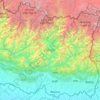
Name: Eastern Development Region topographic map, elevation, terrain.
Location: Eastern Development Region, Nepal (26.34776 86.13113 28.11375 88.20153)
Average elevation: 2,220 m
Minimum elevation: 52 m
Maximum elevation: 8,550 m
Other topographic maps
Click on a map to view its topography, its elevation and its terrain.
Mount Everest
Nepal > Eastern Development Region > Khumjung
Mount Everest, Khumjung, Solukhumbu, Sagarmatha, Eastern Development Region, Nepal
Average elevation: 7,841 m
Makalu
Nepal > Eastern Development Region > Makalu
Makalu, Sankhuwasabha, Koshi, Eastern Development Region, Nepal
Average elevation: 4,068 m
Mera Peak
Nepal > Eastern Development Region > Bung
Mera Peak, Bung, Solukhumbu, Sagarmatha, Eastern Development Region, Nepal
Average elevation: 5,709 m
Lelep
Nepal > Eastern Development Region > Lelep
Lelep, Taplejung, Mechi, Eastern Development Region, Nepal
Average elevation: 4,382 m
Daulatpur
Nepal > Eastern Development Region > Daulatpur
Daulatpur, Surunga, Saptari, Sagarmatha, Eastern Development Region, Nepal
Average elevation: 122 m
Narayanganj
Nepal > Eastern Development Region > Narayanganj
Narayanganj, Mechinagar, Jhapa, Eastern Development Region, Nepal
Average elevation: 282 m
Lhotse Shar
Nepal > Eastern Development Region > Khumjung
Lhotse Shar, Khumjung, Solukhumbu, Sagarmatha, Eastern Development Region, Nepal
Average elevation: 7,153 m
Durgapur
Nepal > Eastern Development Region > Durgapur
Durgapur, Siraha, Sagarmatha, Eastern Development Region, Nepal
Average elevation: 110 m
Boya
Nepal > Eastern Development Region > Boya
Boya, Bhojpur, Koshi, Eastern Development Region, Nepal
Average elevation: 1,448 m