
Hamipré topographic map
Interactive map
Click on the map to display elevation.
About this map
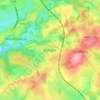
Name: Hamipré topographic map, elevation, terrain.
Average elevation: 446 m
Minimum elevation: 383 m
Maximum elevation: 518 m
Other topographic maps
Click on a map to view its topography, its elevation and its terrain.
Namoussart
Belgique > Luxembourg > Neufchâteau > Hamipre
Namoussart, Hamipre, Neufchâteau, Luxembourg, Wallonie, Belgique
Average elevation: 467 m
Marbay
Belgique > Luxembourg > Neufchâteau > Hamipre > Marbay
Marbay, Hamipre, Neufchâteau, Luxembourg, Wallonie, Belgique
Average elevation: 459 m