
Namoussart topographic map
Interactive map
Click on the map to display elevation.
About this map
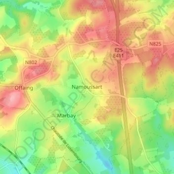
Name: Namoussart topographic map, elevation, terrain.
Location: Namoussart, Hamipre, Neufchâteau, Luxembourg, Wallonie, Belgique (49.81547 5.47949 49.85547 5.51949)
Average elevation: 467 m
Minimum elevation: 411 m
Maximum elevation: 518 m
Other topographic maps
Click on a map to view its topography, its elevation and its terrain.
Marbay
Belgique > Luxembourg > Neufchâteau > Hamipre > Marbay
Marbay, Hamipre, Neufchâteau, Luxembourg, Wallonie, Belgique
Average elevation: 459 m
Hamipré
Belgique > Luxembourg > Neufchâteau > Hamipre
Hamipré, Hamipre, Neufchâteau, Luxembourg, Wallonie, 6840, Belgique
Average elevation: 446 m