
Thank you for supporting this site ❤️
Make a donation
Make a donation
Valcourt (Canton) topographic map
Click on the map to display elevation.
Thank you for supporting this site ❤️
Make a donation
Make a donation
About this map
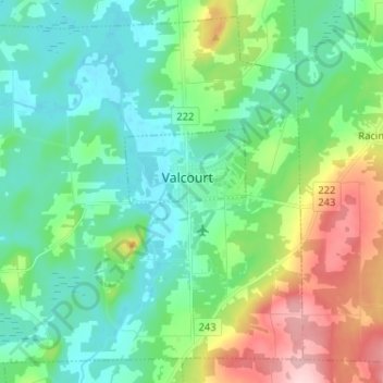
Name: Valcourt (Canton) topographic map, elevation, terrain.
Average elevation: 250 m
Minimum elevation: 191 m
Maximum elevation: 404 m
Thank you for supporting this site ❤️
Make a donation
Make a donation
Other topographic maps
Click on a map to view its topography, its elevation and its terrain.
Thank you for supporting this site ❤️
Make a donation
Make a donation
Mont Chapman
Canada > Québec > Le Val-Saint-François > Stoke
Le mont Chapman est une montagne s'élevant à 658 mètres d'altitude au pic Bald dans les monts Stoke, dont il est le point culminant, dans les monts Notre-Dame méridionaux. Il est situé à Stoke, au Québec, près de la rivière Saint-François. Il est accessible par des sentiers entretenus par Les…
Average elevation: 478 m
Thank you for supporting this site ❤️
Make a donation
Make a donation
Subdivision Danville
Canada > Québec > Le Val-Saint-François > Ville de Richmond
Average elevation: 151 m