
Thank you for supporting this site ❤️
Make a donation
Make a donation
Kraainem topographic map
Click on the map to display elevation.
Thank you for supporting this site ❤️
Make a donation
Make a donation
About this map
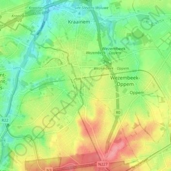
Name: Kraainem topographic map, elevation, terrain.
Location: Kraainem, Hal-Vilvorde, Brabant flamand, 1950, Belgique (50.81828 4.44922 50.86718 4.49293)
Average elevation: 71 m
Minimum elevation: 34 m
Maximum elevation: 122 m
Thank you for supporting this site ❤️
Make a donation
Make a donation
Other topographic maps
Click on a map to view its topography, its elevation and its terrain.
Thank you for supporting this site ❤️
Make a donation
Make a donation
Thank you for supporting this site ❤️
Make a donation
Make a donation
Thank you for supporting this site ❤️
Make a donation
Make a donation
Château d'Ophem
Belgique > Brabant flamand > Hal-Vilvorde > Wezembeek-Oppem > Ophem
Average elevation: 75 m
Thank you for supporting this site ❤️
Make a donation
Make a donation
Thank you for supporting this site ❤️
Make a donation
Make a donation
Wezembeek
Belgique > Brabant flamand > Hal-Vilvorde > Wesembeek-Ophem > Wesembeek
Average elevation: 63 m
Thank you for supporting this site ❤️
Make a donation
Make a donation
Rattendaal
Belgique > Brabant flamand > Hal-Vilvorde > Leeuw-Saint-Pierre > Rattendaal
Average elevation: 39 m
Thank you for supporting this site ❤️
Make a donation
Make a donation