
Make a donation
Bonsecours topographic map
Click on the map to display elevation.
Make a donation
About this map
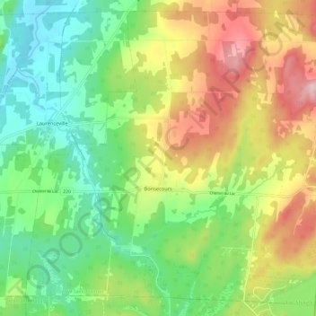
Name: Bonsecours topographic map, elevation, terrain.
Location: Bonsecours, Le Val-Saint-François, Québec, J0E 1H0, Canada (45.37456 -72.35462 45.45111 -72.23769)
Average elevation: 295 m
Minimum elevation: 196 m
Maximum elevation: 447 m
Make a donation
Other topographic maps
Click on a map to view its topography, its elevation and its terrain.
Make a donation
Mont Chapman
Canada > Québec > Le Val-Saint-François > Stoke
Le mont Chapman est une montagne s'élevant à 658 mètres d'altitude au pic Bald dans les monts Stoke, dont il est le point culminant, dans les monts Notre-Dame méridionaux. Il est situé à Stoke, au Québec, près de la rivière Saint-François. Il est accessible par des sentiers entretenus par Les…
Average elevation: 478 m
Make a donation
Subdivision Danville
Canada > Québec > Le Val-Saint-François > Ville de Richmond
Average elevation: 151 m