
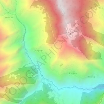
Chilime Khola topographic map
Interactive map
Click on the map to display elevation.
About this map
Name: Chilime Khola topographic map, elevation, terrain.
Average elevation: 2,388 m
Minimum elevation: 1,563 m
Maximum elevation: 3,341 m
Other topographic maps
Click on a map to view its topography, its elevation and its terrain.
Bharatpur
Nepal > Central Development Region > Bharatpur
Bharatpur, Chitwan, Narayani, Central Development Region, 056, Nepal
Average elevation: 363 m
Chillime
Nepal > Central Development Region > Chillime
Chillime, Rasuwa, Bagmati, Central Development Region, Nepal
Average elevation: 2,194 m
Janakpur
Nepal > Central Development Region
Janakpur, Central Development Region, Nepal
Average elevation: 1,600 m
Central Development Region
Nepal > Central Development Region
Central Development Region, Nepal
Average elevation: 1,546 m
Chhaling
Nepal > Central Development Region > Bhaktapur
Chhaling, Bhaktapur, Bagmati, Central Development Region, 48000, Nepal
Average elevation: 1,399 m