
Central Development Region topographic map
Interactive map
Click on the map to display elevation.
About this map
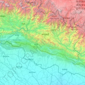
Name: Central Development Region topographic map, elevation, terrain.
Location: Central Development Region, Nepal (26.56802 83.91936 28.38583 86.57262)
Average elevation: 1,546 m
Minimum elevation: 50 m
Maximum elevation: 7,949 m
Other topographic maps
Click on a map to view its topography, its elevation and its terrain.
Chilime Khola
Nepal > Central Development Region
Chilime Khola, Rasuwa, Bagmati, Central Development Region, Nepal
Average elevation: 2,388 m
Bharatpur
Nepal > Central Development Region > Bharatpur
Bharatpur, Chitwan, Narayani, Central Development Region, 056, Nepal
Average elevation: 363 m
Chillime
Nepal > Central Development Region > Chillime
Chillime, Rasuwa, Bagmati, Central Development Region, Nepal
Average elevation: 2,194 m
Janakpur
Nepal > Central Development Region
Janakpur, Central Development Region, Nepal
Average elevation: 1,600 m