Geolocate

Coloretta topographic map

Click on the map to display elevation.

About this map

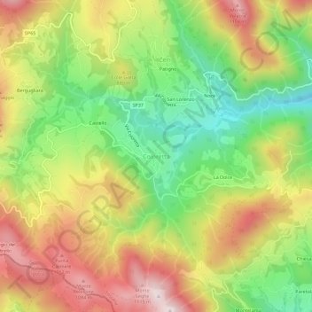
Name: Coloretta topographic map, elevation, terrain.

Location: Coloretta, Zeri, Unione di comuni Montana Lunigiana, Massa-Carrara, Tuscany, 54029, Italy (44.32131 9.74183 44.36131 9.78183)

Average elevation: 817 m

Minimum elevation: 523 m

Maximum elevation: 1,139 m

Other topographic maps

Click on a map to view its topography, its elevation and its terrain.

Florence

Italy > Tuscany > Florence

Average elevation: 142 m

San Quirico d'Orcia

Italy > Tuscany > Siena

Average elevation: 318 m

Montespertoli

Italy > Tuscany > Florence

Average elevation: 162 m

Carrara

Italy > Tuscany

Average elevation: 377 m

Calenzano

Italy > Tuscany > Florence

Average elevation: 300 m

Buonconvento

Italy > Tuscany > Siena

Average elevation: 192 m

Florence

Italy > Tuscany > Florence

Average elevation: 142 m

Campagnatico

Italy > Tuscany > Grosseto

Average elevation: 142 m

Pontremoli

Italy > Tuscany

Average elevation: 750 m

Arezzo

Italy > Tuscany

Average elevation: 475 m

Isola del Giglio

Italy > Tuscany > Grosseto > Giglio Porto

Average elevation: 57 m

Seggiano

Italy > Tuscany > Grosseto

With the exception of units of low hill near the beds of rivers, the region extends mainly in hilly and mountainous odds, but good exposure allows the cultivation of a cultivar of olive, Olivastra Seggianese, called up to elevations of low mountains, managing to produce an oil of excellent quality.

Average elevation: 550 m

Giardino Bruna Talluri

Italy > Tuscany > Siena > Siena

Average elevation: 311 m

Poppi

Italy > Tuscany > Arezzo

Average elevation: 661 m

Palazzuolo sul Senio

Italy > Tuscany > Florence

Average elevation: 655 m

Barga

Italy > Tuscany > Lucca

Average elevation: 624 m

Sorano

Italy > Tuscany > Grosseto

Average elevation: 457 m

Bagno a Ripoli

Italy > Tuscany > Florence

Average elevation: 210 m

Greve in Chianti

Italy > Tuscany > Florence

Average elevation: 364 m

Montescudaio

Italy > Tuscany > Pisa

Average elevation: 111 m

Castelfiorentino

Italy > Tuscany > Florence

Average elevation: 98 m

Asciano

Italy > Tuscany > Siena

Average elevation: 285 m

Sinalunga

Italy > Tuscany > Siena

Average elevation: 320 m

Cortona

Italy > Tuscany > Arezzo

The prevailing character of Cortona's architecture is medieval with steep narrow streets situated on a hillside at an elevation of 600 metres (2,000 ft) that embraces a view of the whole of the Valdichiana. From the Piazza Garibaldi (still referred to by the local population by its older name, Piazza…

Average elevation: 375 m

Suvereto

Italy > Tuscany > Livorno

Average elevation: 117 m

Casole d'Elsa

Italy > Tuscany > Siena

Average elevation: 315 m

Siena

Italy > Tuscany

Average elevation: 335 m

Prato

Italy > Tuscany

Average elevation: 390 m

Campagnatico

Italy > Tuscany > Grosseto

Average elevation: 142 m

Minucciano

Italy > Tuscany > Lucca

Average elevation: 798 m

San Gimignano

Italy > Tuscany > Siena

The municipality of San Gimignano extends for 138 km² and is located on a hill in Val d'Elsa. The altitude difference is between a minimum of 64 meters a.s.l. in the plain of the river Elsa near Certaldo at a maximum of 631 meters in the area of Cornocchio.

Average elevation: 239 m

Signa

Italy > Tuscany > Florence

Average elevation: 48 m

Massa

Italy > Tuscany

Average elevation: 383 m

Pisa

Italy > Tuscany > Pisa

Average elevation: 11 m

Pelago

Italy > Tuscany > Florence

Average elevation: 481 m

Montescudaio

Italy > Tuscany > Pisa

Average elevation: 111 m

Massa

Italy > Tuscany

Average elevation: 383 m

Siena

Italy > Tuscany

Average elevation: 335 m

Radicondoli

Italy > Tuscany > Siena

Average elevation: 410 m

Pisa

Italy > Tuscany

Average elevation: 137 m

San Gimignano

Italy > Tuscany > Siena

The municipality of San Gimignano extends for 138 km² and is located on a hill in Val d'Elsa. The altitude difference is between a minimum of 64 meters a.s.l. in the plain of the river Elsa near Certaldo at a maximum of 631 meters in the area of Cornocchio.

Average elevation: 239 m

Reggello

Italy > Tuscany > Florence

Average elevation: 584 m

Grosseto

Italy > Tuscany

The Province of Grosseto completely occupies the southern end of Tuscany, and with a territorial area of 4,504 square kilometres (1,739 sq mi), it is the most extensive in the region and one of the least dense in population in Italy. The province is bordered to the northwest by the Province of Livorno, to the…

Average elevation: 197 m

Livorno

Italy > Tuscany

Average elevation: 61 m

Collesalvetti

Italy > Tuscany > Livorno

Average elevation: 78 m

Lucca

Italy > Tuscany

Average elevation: 560 m

Florence

Italy > Tuscany > Florence

Average elevation: 142 m

Livorno

Italy > Tuscany

Average elevation: 61 m

Lucca

Italy > Tuscany

Average elevation: 560 m

Chianni

Italy > Tuscany > Pisa

Average elevation: 300 m

Firenzuola

Italy > Tuscany > Florence

Average elevation: 668 m

Bagnone

Italy > Tuscany

Bagnone is a comune (municipality) in the Province of Massa and Carrara in the Italian region Tuscany, located about 120 kilometres (75 mi) northwest of Florence and about 35 kilometres (22 mi) northwest of Massa in the Lunigiana, facing the Monte Sillara, which has a peak elevation of 1,861 metres (6,106 ft).…

Average elevation: 568 m

Trequanda

Italy > Tuscany > Siena

Average elevation: 375 m

Dicomano

Italy > Tuscany > Florence

Average elevation: 515 m

Borgo a Mozzano

Italy > Tuscany > Lucca

Average elevation: 439 m

Camporgiano

Italy > Tuscany > Lucca

Average elevation: 657 m

Piazza al Serchio

Italy > Tuscany > Lucca

Average elevation: 831 m

Radda in Chianti

Italy > Tuscany > Siena

Average elevation: 484 m

Chiusi della Verna

Italy > Tuscany > Arezzo

Average elevation: 773 m

Pistoia

Italy > Tuscany

Average elevation: 530 m

Certaldo

Italy > Tuscany > Florence

Average elevation: 128 m

Fiesole

Italy > Tuscany > Florence

Average elevation: 265 m

Pescia

Italy > Tuscany > Pistoia

Average elevation: 438 m

Prato

Italy > Tuscany > Prato

Prato (/ˈprɑːtoʊ/ PRAH-toh; Italian: [ˈpraːto] ) is a city and municipality (comune) in Tuscany, Italy, and is the capital of the province of Prato. The city lies in the northeast of Tuscany, at an elevation of 65 metres (213 ft), at the foot of Monte Retaia (the last peak in the Calvana chain). With…

Average elevation: 148 m

Greve in Chianti

Italy > Tuscany > Florence

Average elevation: 364 m

Prato

Italy > Tuscany > Prato

Prato (/ˈprɑːtoʊ/ PRAH-toh; Italian: [ˈpraːto] ) is a city and municipality (comune) in Tuscany, Italy, and is the capital of the province of Prato. The city lies in the northeast of Tuscany, at an elevation of 65 metres (213 ft), at the foot of Monte Retaia (the last peak in the Calvana chain). With…

Average elevation: 148 m

Pomarance

Italy > Tuscany > Pisa

Average elevation: 342 m

Castelnuovo di Val di Cecina

Italy > Tuscany > Pisa

Average elevation: 424 m

Viareggio

Italy > Tuscany > Lucca

Average elevation: 1 m

Pomarance

Italy > Tuscany > Pisa

Average elevation: 342 m

Vicchio

Italy > Tuscany > Florence

Average elevation: 447 m

Radicofani

Italy > Tuscany > Siena

Average elevation: 541 m

Treppio

Italy > Tuscany > Pistoia

Average elevation: 787 m

Carrara

Italy > Tuscany

Average elevation: 377 m

Certaldo

Italy > Tuscany > Florence

Average elevation: 128 m

Livorno

Italy > Tuscany > Livorno

Average elevation: 26 m

Florence

Italy > Tuscany > Florence

Average elevation: 142 m

Gaiole in Chianti

Italy > Tuscany > Siena

Average elevation: 433 m

Terricciola

Italy > Tuscany > Pisa

Average elevation: 94 m

Montemurlo

Italy > Tuscany > Prato

Average elevation: 278 m

Careggine

Italy > Tuscany > Lucca

Average elevation: 814 m

Villa Basilica

Italy > Tuscany > Lucca

Average elevation: 626 m

Florence

Italy > Tuscany > Florence

Average elevation: 142 m

Chiusi

Italy > Tuscany > Siena

Average elevation: 294 m

Siena

Italy > Tuscany

Average elevation: 335 m

Bagnone

Italy > Tuscany

Bagnone is a comune (municipality) in the Province of Massa and Carrara in the Italian region Tuscany, located about 120 kilometres (75 mi) northwest of Florence and about 35 kilometres (22 mi) northwest of Massa in the Lunigiana, facing the Monte Sillara, which has a peak elevation of 1,861 metres (6,106 ft).…

Average elevation: 568 m

Belverde

Italy > Tuscany > Siena > Monteriggioni

Average elevation: 328 m

Prato

Italy > Tuscany

Average elevation: 390 m

Montepulciano

Italy > Tuscany > Siena

Average elevation: 374 m

Fabbriche di Vergemoli

Italy > Tuscany > Lucca

Average elevation: 712 m

Minucciano

Italy > Tuscany > Lucca

Average elevation: 798 m

Pienza

Italy > Tuscany > Siena

Average elevation: 394 m

Gallicano

Italy > Tuscany > Lucca

Average elevation: 480 m

Livorno

Italy > Tuscany > Livorno

Average elevation: 26 m

Siena

Italy > Tuscany

Average elevation: 335 m

Pienza

Italy > Tuscany > Siena

Average elevation: 394 m

Val d'Orcia

Italy > Tuscany > Siena

Average elevation: 429 m

Cortona

Italy > Tuscany > Arezzo

The prevailing character of Cortona's architecture is medieval with steep narrow streets situated on a hillside at an elevation of 600 metres (2,000 ft) that embraces a view of the whole of the Valdichiana. From the Piazza Garibaldi (still referred to by the local population by its older name, Piazza…

Average elevation: 375 m

Villafranca in Lunigiana

Italy > Tuscany

Average elevation: 303 m