
Make a donation
South America topographic map
Click on the map to display elevation.
Make a donation
South America
South America's topography is marked by remarkable diversity and dramatic contrasts. The continent is dominated by the Andes mountain range, which runs along its western edge, stretching over 4,300 miles from Venezuela to Chile. These mountains are home to some of the highest peaks in the Western Hemisphere, including Aconcagua, which rises to 22,841 feet. To the east of the Andes lies the expansive Amazon Basin, encompassing nearly 2.7 million square miles and characterized by dense rainforests that are teeming with biodiversity. The basin is fed by numerous tributaries, including the mighty Amazon River, which discharges vast volumes of water into the Atlantic Ocean. Meanwhile, the eastern regions feature the fertile Pampas, a vast grassland ideal for agriculture, and the semi-arid regions of Patagonia, known for its rugged terrain and sparse rainfall due to the rain shadow effect of the Andes. Notably, the Atacama Desert, situated along the Pacific coast, is recognized as the driest non-polar desert in the world, showcasing the continent's extreme climatic conditions and geographical variety.
Make a donation
About this map
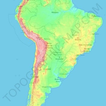
Name: South America topographic map, elevation, terrain.
Location: South America (-46.00022 -86.00066 3.99978 -36.00066)
Average elevation: 283 m
Minimum elevation: -1 m
Maximum elevation: 6,497 m
Make a donation
Other topographic maps
Click on a map to view its topography, its elevation and its terrain.
Singapore
The Central Region of Singapore, encompassing approximately 132.7 square kilometers (51.2 square miles), features a diverse topography characterized by both hilly terrains and flat coastal areas. Dominating the landscape is Bukit Timah Hill, the nation's highest natural point at 164 meters (538 feet), composed…
Average elevation: 11 m
Qatar
Average elevation: 20 m
Indonesia
Indonesia's topography is as varied as its expansive archipelago, marked by rugged mountain ranges, volcanic activity, and vast lowland plains. The majority of its major islands are mountainous, with some of the highest peaks rising above 16,000 feet (4,877 meters), such as Puncak Jaya in Papua. These…
Average elevation: 81 m
Make a donation
Singapore
Average elevation: 14 m
Make a donation
Make a donation
Cebu
Coal was first discovered in Cebu about 1837. There were 15 localities over the whole island, on both coasts; some desultory mining had been carried out Naga near Mount Uling, but most serious operations were at Licos and Camansi west of Compostela and Danao. Active work ceased about 1895 with the…
Average elevation: 91 m
Make a donation
Make a donation
Saudi Arabia
Saudi Arabia's diverse geography is dominated by the Arabian Desert, associated semi-desert, shrubland, steppes, several mountain ranges, volcanic lava fields and highlands. The 647,500 km2 (250,001 sq mi) Rub' al Khali ("Empty Quarter") in the southeastern part of the country is the world's largest contiguous…
Average elevation: 551 m
Tehran
Iran > Tehran Province > Tehran County
Northern Tehran is at the foot of Alborz, starting at an elevation of 1,800 meters (5,900 ft), with many houses and streets on steep slopes and hills. There is a stretch of hills in the middle of the city (which historically divided Tehran and Shemiran) with its highest point at 1,500 metres (4,900 ft).…
Average elevation: 1,539 m
Make a donation
Wonosobo
Wonosobo has an elevation moderated tropical rainforest climate (Af) with moderate rainfall from July to September and heavy to very heavy rainfall in the remaining months. The following climate data is for the town of Wonosobo.
Average elevation: 876 m
Make a donation
Amasra
In the late 8th century its bishop obtained from the Byzantine Emperor its elevation to the rank of autocephalous archeparchy. It is listed as such in the Notitia Episcopatuum attributed to Basil the Armenian (c. 840) and in that of Leo VI the Wise (early 10th century).
Average elevation: 121 m
Make a donation
Salin Township
Myanmar > Magway > Minbu District
Salin Township lies along the Irrawaddy River in central Myanmar's Dry Zone region. It is predominantly a low-lying part of the Irrawaddy valley with the elevation rising towards its west where some hills can be found. The most prominent mountain is Mt. Nwama in the township's west, but the highest point, Mt.…
Average elevation: 172 m
Make a donation
Make a donation
Make a donation
Bangladesh
Bangladesh is predominantly rich fertile flat land. Most of it is less than 12 m (39 ft) above sea level, and it is estimated that about 10% of its land would be flooded if the sea level were to rise by 1 m (3.3 ft). 12% of the country is covered by hill systems. The country's haor wetlands are of significance…
Average elevation: 161 m
Make a donation
Make a donation
Make a donation
Denmark
The Kingdom of Denmark, including the Faroe Islands and Greenland, has roughly 1,400 islands greater than 100 square metres (1,100 sq ft) in area; 443 have been named and 78 are inhabited. Denmark's population is over 6 million (1 May 2025), of which roughly 40% live in Zealand, (Sjælland) the largest and…
Average elevation: 30 m
Make a donation
Chihuahua
The main mountain range in the state is the Sierra Madre Occidental reaching a maximum altitude of 10,826 ft (3,300 m) known as Cerro Mohinora. Mountains account for one third of the state's surface area which include large coniferous forests. The climate in the mountainous regions varies. Chihuahua has more…
Average elevation: 1,397 m
Make a donation
Make a donation
Make a donation
Tirana
Albania > Central Albania > Tirana County
Tirana extends at the Plain of Tirana in the centre of Albania between the mount of Dajti in the east, the hills of Kërrabe, Sauk and Vaqarr in the south, and a valley to the north overlooking the Adriatic Sea. The average altitude is about 110 meters (360 ft) above sea level, with a maximum of 1,828 metres…
Average elevation: 146 m
Make a donation
Make a donation
Philippines
Its highest mountain is Mount Apo on Mindanao, with an altitude of 2,954 meters (9,692 ft) above sea level. The Philippines' longest river is the Cagayan River in northern Luzon, which flows for about 520 kilometers (320 mi). Manila Bay, on which is the capital city of Manila, is connected to Laguna de Bay…
Average elevation: 33 m
Make a donation
Surrey
United Kingdom > England > Surrey
The highest elevation in Surrey is Leith Hill near Dorking. It is 295 m (968 ft) above sea level and is the second highest point in southeastern England after Walbury Hill in West Berkshire which is 297 m (974 ft).
Average elevation: 69 m
Make a donation
La Paz
Bolivia > La Paz > Pedro Domingo Murillo
Located in west-central Bolivia 68 km (42 mi) southeast of Lake Titicaca, La Paz is set in a canyon created by the Choqueyapu River. It is in a bowl-like depression, part of the Amazon basin, surrounded by the high mountains of the Altiplano. Overlooking the city is the triple-peaked Illimani. Its peaks are…
Average elevation: 3,544 m
Make a donation
Lipa
At the celebration of the elevation of Lipa to a city in January 1888, José Rizal was invited by Dr. Jose Lozada, Catalino Dimayuga and the brothers Celestino and Simeon Luz but Rizal responded only with his Hymno Al Trabajo which he dedicated to the zeal and industry of the Lipeños.
Average elevation: 208 m
Bronx County
United States > New York > New York
The Bronx's highest elevation at 280 feet (85 m) is in the northwest corner, west of Van Cortlandt Park and in the Chapel Farm area near the Riverdale Country School. The opposite (southeastern) side of the Bronx has four large low peninsulas or "necks" of low-lying land that jut into the waters of the East…
Average elevation: 15 m
Nantes
France > Pays de la Loire > Loire-Atlantique
Nantes is built on the Armorican Massif, a range of weathered mountains which may be considered the backbone of Brittany. The mountains, stretching from the end of the Breton peninsula to the outskirts of the sedimentary Paris Basin, are composed of several parallel ridges of Ordovician and Cadomian rocks.…
Average elevation: 26 m
Make a donation
Make a donation